A remote forest monitoring system
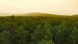
Forests are critical components of many global ecosystems. If they are to continue soaking up carbon and providing renewable products and energy, forests must be carefully managed using all the tools available. The EU-funded initiative THERMOLIDAR (A new tool for sustainable forest management based on LIDAR (laser imaging detection and ranging) and thermal data integration) created software combining remote sensing and thermal imaging data to help forest managers monitor the health of their forests. Inventories containing data on forest structure and physiological states of trees are a key component of forest management. Current methods for collecting such data are time consuming and costly, usually relying on manual measurements on the ground with hand-held equipment. THERMOLIDAR instead used LiDAR to create high-resolution maps of forested areas from satellite data. This technique uses aerial sensors to illuminate the forests with a laser and provides structural information by measuring the refracted light. To monitor forest tree health, researchers used remote thermal sensors that supply physiological information based on temperature differences at the tops of canopies. Such heat maps can provide forest managers with critical early warning signs of stresses like drought or disease before they are otherwise visible. To integrate LiDAR-based structural information with thermal-based physiological data, THERMOLIDAR created sophisticated software that converts raw data into maps and models of forest health. Researchers then tested and validated their software using data collected from different forest ecosystems in the Czech Republic, Spain, Finland and the United Kingdom. They found no correlation between canopy temperature and stress, and no differences in heat maps between healthy and infected trees. This was due to remote sensors measuring not just canopy temperatures but also those of unrelated air, branches and shadows. This technique therefore needs to be refined before it can be applied on a wide scale. Overall, THERMOLIDAR's tool for assessing large forests remotely should significantly improve forest management and help foresters in charge of large forest areas to make decisions.
Keywords
Forest, forest management, LiDAR, remote sensing, thermal imaging, satellite data