Better managing our deep-sea resources
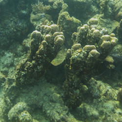
The purpose of the CORALFISH project was to improve the scientific basis for the sustainable exploitation of deep-sea resources while ensuring adequate protection for vulnerable marine ecosystems (VMEs). This responded directly to a call by the UN General Assembly Resolution 61/105 to prevent impacts from bottom fishing on VMEs in the world's oceans. Sustainable exploitation and management of marine resources and conservation of fragile habitats requires data on where VMEs occur and an understanding of how these ecosystems function and how fish interact with them. In Europe's offshore waters, the main VMEs are cold-water corals and sponge habitats. Although these environments are important to commercial fish, with 63 species recorded there, they are easily damaged by fishing activities. Failure to manage fisheries without taking into account a larger ecosystem perspective can therefore have economic consequences for fisheries. This is because habitat loss over time will result in a decrease in the amount of fish that can be supported. The field intensive CORALFISH project collected data during 27 research expeditions enabling the production of the first comprehensive catalogue of seafloor maps of European coral habitat. The development of standard methodologies and tools, including ‘COVER’ – software to improve the standard annotation of video - and semi-automated GIS classification tools, ensured uniformity of map production. Notwithstanding this impressive effort to collect new data, the footprint of sampled seafloor remains minuscule at the scale of ocean basins. The CORALFISH project therefore developed innovative mapping and predictive modelling approaches to compensate for the paucity of knowledge of biology over vast areas of the world's oceans. Novel habitat suitability models enabled the production of predicted habitat distribution maps of corals at global, regional and local levels. These maps can be used as decision support tools for policymakers and planners involved in offshore spatial planning in areas where little field data is available. Outputs from the CORALFISH project have made an important contribution to the debate surrounding the future viability of deep-sea fisheries in Europe and will in the future contribute to planned initiatives as part of the European Commission's maritime strategy.
Keywords
Cold water corals, deep-sea fisheries, fishing activities, bottom fishing, marine ecosystem