Cheaper, less invasive animal tracking takes off
The consequences of climate change are unfolding before our very eyes. Among these is what experts have come to call ‘the sixth mass extinction’, which threatens to wipe out over half of Earth’s remaining species. Determining where and how this extinction takes place is key to taking appropriate countermeasures. And for that, we notably need animal tracking data. “Studies on wild animals require the ability to find them and download data from their collars,” says Alan Wilson, professor of Locomotor Biomechanics at the Royal Veterinary College, United Kingdom. “Usually, the animals are found using a radio beacon or GNSS receiver. Downloading the data, however, always requires observers to drive close to the animal and use a handheld radio receiver.” That was all before the ERC-funded AIRSCAN (A customised low-cost ultralight aircraft for survey, filming and animal tracking in wild environments) project came to fruition. In February 2020, Wilson and his team proposed a new generation of low-cost, ultralight aircraft to track animals in their natural environment. With this aircraft – which boasts a very low operating cost of approximately EUR 30 per hour – and its integrated onboard data collection technologies, the pilot can perform aerial surveys, film animal populations and download data directly from the air. “Invading a wild animal’s space and potentially putting the researcher at risk is just not necessary anymore. Our Trail ADAP (aerial data collection platform) aircraft can retrieve collar data by flying within 200-300 metres of the animal. This obviates the need to travel long distances overland and approach the animals on the ground,” Wilson explains. Most importantly, the Trail ADAP is ultralight. It can take off from a dirt or grass airstrip and easily fits into a road trailer or shipping container. Benefits for the animal tracking community are considerable. Areas where ground access would be impossible due to topography or vegetation density are now within reach. So are those areas where such access is risky or too time-consuming.
Unique data sets
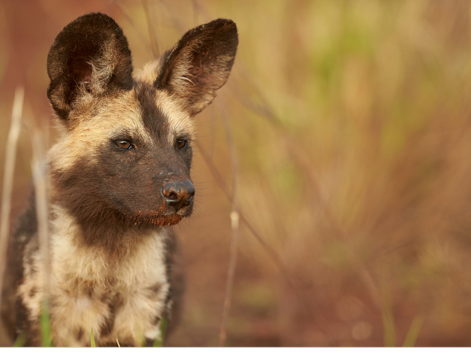
The value of the retrieved information increases as well. Since the Trail ADAP is equipped with LIDAR and video cameras to conduct surveys of the ground and vegetation, it enables analysis of the tracking data in the context of the animal’s environment. “We have used our survey equipment to capture the hunting terrain of African wild dogs. The idea was to explore how they hunt in vegetation, flushing prey out of cover. In the same spirit, we used our equipment to explore how zebras navigate in their habitat, what trails they are following and whether they are loyal to particular routes,” Wilson adds. Besides wild dogs and zebras, the team studied the likes of cheetahs, leopards, lions and their prey in the vast savannah of northern Botswana. While other methods would have been impractical there, the Trail ADAP collected a uniquely detailed data set. In a context of endangered biodiversity, there is little doubt that the Trail ADAP can help wildlife conservation and management. Although the project is completed, Wilson and his team have continued plans to use it in southern Africa – where they are seeking funding for new challenging projects on wildlife ecology – and in the United Kingdom where they want to study the aerodynamics of bird flight. How about other applications? Several organisations usually using helicopters to conduct aerial surveys of infrastructure such as railways and pipelines have already shown interest in the aircraft and its much lower operating cost. “Trail ADAP will soon be available for purchase through aircraft manufacturer Groppo Ing. in Italy. It has great potential to transform aerial data collection in a wide range of disciplines and applications,” Wilson concludes.