New insights into landslides, floods and erosion
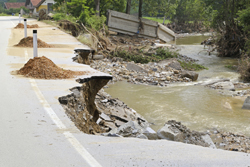
Landslides, floods and erosion, which are often caused by earthquakes, can severely impact rivers, destroy surrounding road infrastructure and destabilise nearby communities. This has prompted researchers to seek ways of predicting the catchment response to large earthquakes that could trigger extensive landslides in vulnerable regions of the world. The EU-funded project ROSNZ sought to develop a new approach to explore such phenomena. Looking at the Southern Alps of New Zealand, the project team explored the complex two-dimensional (2D) dynamics and gathered new data on the impact of landslides on river evolution. It worked on developing an advanced numerical model of mountain landscape evolution incorporating a new bedrock landsliding algorithm. To achieve its aims, the team studied the impact of landslides and floods on channel morphology using repeat terrestrial light detection and ranging (LIDAR) surveys of rapidly incising rivers. It analysed seven landslide-affected bedrock areas in two rivers, comparing data before and after a 10-year return flood in one river to reveal important data on understanding landslides. Another achievement involved documenting the impact of a large storm on a gorge that resulted in heavy landslides. Overall, the project team showed the interplay among large rock falls, cliff failure, erosion and landslides that could cause river deviation. A major contribution in this respect was the development of two open-source software solutions for the advanced processing of LIDAR datasets that could significantly further the geomorphology and geoscience involved. The project produced a valuable dataset on the dominant role of stochastic floods and thresholds in nature, also exploring the combined effect of stochastic landsliding and flooding on landscape dynamics. The findings and practical tools emerging from this project can be used by geoscientists to monitor and assess geohazards based on terrestrial LIDAR data and landscape evolution simulations. Progress in this area will help understand sedimentary hazards in New Zealand's Southern Alps and may contribute to strategies for studying similar issues worldwide.