3D map of Earth's interior
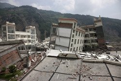
When a major earthquake strikes, seismic waves ripple through the surrounding region, toppling houses over and swaying commercial buildings. Though destructive, seismic events help geoscientists better understand Earth's internal structure. The technique of eavesdropping on seismic waves, as they pass through Earth, allows the detection of structures such as hydrocarbon or mineral deposits and magma upswelling. Aided by a growing network of seismographs and superfast computers, EU-funded geoscientists used seismic tomography to explore our planet's interior. The ultimate goal of the 'Quantitative estimation of Earth's seismic sources and structure' (QUEST)(opens in new window) project was to produce a 3D map on regional and global scales. Geoscientists were particularly interested in the precise locations of tectonic plates, which can trigger earthquakes when they slide against each other. During the project's four-year lifetime, the team was at the forefront of research on how to improve this technique, which is analogous to computerised tomography used in medical scans. QUEST partners pioneered methodologies for using much more of the information in seismograms recording seismic vibrations of quakes. Data from seismograms for many earthquakes were fed into a computer model that simulates each wave as it rumbles away from the earthquake's epicentre. The resulting 'synthetic' seismograms were compared to real seismograms and identified differences were then fed back into the model to improve it. To map the Earth's internal structure in sufficient detail required highly complex calculations that can only be carried out by powerful supercomputers. PRACE offered processors so fast that the QUEST techniques were set to change seismic tomography at a fundamental level. The QUEST project was heavily influenced by an 8.7-magnitude earthquake that struck the central Chilean region Maule in 2010 and a 9-magnitude earthquake on Japan's main island Honshu in 2011. Nonetheless, scientists showed that the new methodologies worked for Europe as a whole as well as for smaller regions, like the Alps. In addition, substantial progress could be made using ocean generated ambient seismic noise to image the Earth’s interior and monitor its changes with time. More than 30 research groups from academia and industry joined their efforts to map Earth's interior in 3D, which could lead to more accurate predictions of damage from earthquakes.