Smart observation from ground and space provides protection from earthquakes and eruptions
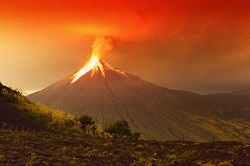
As is all too often evidenced, effective emergency response relies on accurate and timely information. With data comes from a variety of observational sources, such as satellite and ground sensors, a key challenge is being able interpret this raw data to make it meaningful for effective mitigation or emergency response efforts. The APHORISM project focussed on improving data for seismic and volcanic crisis management, developing two new methods that combined Earth Observation satellite data from different sensors, with that of ground data. As Dr. Merucci, one of the project leaders, points out, ‘These provide more accurate damage mapping products which are extremely useful to mitigate the effects on population and infrastructures.’ Improving damage assessment for earthquakes and eruptions When it comes to seismic events, analysing satellite data to ascertain the scale of damage, is not in itself innovative. However, APHORISM’s innovation with their 'A Priori information for Earthquake’ damage mapping (APE) methodology, was to integrate change detection maps, with situational information from before the event. This a priori data was derived from Interferometric synthetic aperture radar (InSAR) which monitors and measures surface movements, shakemaps derived from seismological data, and vulnerability assessments. As Dr. Merucci recaps, ‘The main step forward was the adoption of novel damage indicators, able to exploit the vulnerability of urban settlements, such as data about structural vulnerability of buildings, completely independent from Earth observation data.’ The second key objective of APHORISM was to develop a system for improved volcanic crisis management. Volcanic eruptions through their emission of gas and solid particles are one of the major natural polluters, often resulting in significant social, economic and environmental impacts. To enhance ash detection, APHORISM developed the Multi-platform volcanic Ash Cloud Estimation (MACE) procedure. As Dr. Merucci explains, ‘The novelty of the MACE approach is that the geostationary instrument sets the pace and the spatial resolution of the ash cloud detection and retrieval. This knowledge is then improved by using additional datasets.’ These datasets included the regular and frequent data acquisition of the SEVIRI sensor on board the Geosynchronous Earth Orbit (GEO) Meteosat Second Generation (MSG) satellite, with the less frequent but higher sensitivity of Low Earth Orbit (LEO) sensors, along with in-situ ground data which is of very high spatial resolution and acquisition frequency, but on a limited area. Additionally, the usual thermal infrared ash retrieval was combined with wider spectral data ranging from visible to microwave and detection was extended to cater for cloudy and steamy conditions. From sensors to Sentinels After being validated against recent relevant historical events, APHORISM’s prime concern was to transform the procedures into deployable products. APE has resulted in the Likelihood Index Damage Map (LIDaM), using very high resolution imagery at the scale of single buildings, and with medium resolution satellite data at the level of groups of buildings. According to Dr. Merucci LIDaM will, ‘ensure a prompt response to aid rescue teams, identifying the most damaged areas where to concentrate rescue activity as well as reduce false alarms.’ In the case of ash detection, Integrated Ash Products (IAPs) have been created, including those which generate mass, effective radius, aerosol optical depth, concentration, and cloud height maps, improving air traffic security. ‘These APHORISM products can enrich the portfolio of Emergency Mapping Services, especially as part of the European Space Agency’s (ESA) Sentinel satellite missions designed to deliver the Copernicus programme,’ summarised Dr Merucci. Copernicus is the world’s largest global monitoring programme, set up to provide environmental management information for marine, land, atmosphere, emergency, security and climate based decision making.