Erosion-risk tools developed for fire-affected volcanic terrain
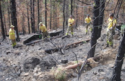
Volcanic regions are frequently highly populated, steep and prone to wildfires. These areas are also often beset by torrential rainfall and as wildfires remove protective vegetation they experience severe water erosion, landslides and floods. Collectively, these pose a significant threat to property, infrastructure, and ultimately lives. The EU-funded FireAndRiskPrevention project has tested and implemented urgently needed erosion-risk tools in the Canary Islands, Spain. These tools were developed to support land managers in the design of effective mitigation plans and protocols to reduce fire-induced hydrologic and erosion risks. After further customisation, the tools are intended to be useful for other vulnerable and remote regions of volcanic origin around the world. Tools forged by field, laboratory and modelling efforts The FireAndRiskPrevention project team started by collating existing knowledge and approaches. Then with the help of local stakeholders they identified critical gaps for improved runoff-erosion processes, in fire-affected volcanic terrain. The next step proved to be perhaps the most challenging as Marie-Curie Fellow Dr Jonay Neris Tomé recalls, “We had to opportunistically ‘chase’ suitable fires for field data.” However, due to their fragile soil structure and subsequent rapid changes in physical and hydrologic properties after environmental disturbances, volcanic soils behave very differently from other soil types. Therefore, the main challenge that land managers face when designing post-fire mitigation actions in volcanic areas is that existing models used to predict runoff-erosion have not been tested specifically for volcanic soils but rather imported from other terrains. Additionally, mitigation interventions themselves have been developed and tested in very different terrain, often using materials not readily available in volcanic areas. Once the suitably burned areas were identified, as Dr Neris Tomé explains, “We modified an existing and widely-used erosion-risk model, the ‘Water Erosion Prediction Project’ of the US Forest Service, to develop tools adapted to the distinctive response of volcanic soils to the impact of fire. We found that these tailored local mitigation treatments - for example using local pine needles as mulch - performed best for this terrain type to reduce runoff and erosion.” Cost-effective future proofing The tools developed by the FireAndRiskPrevention project are currently supporting the Spanish Cabildo de Tenerife management body to design risk reduction mitigation actions in response to the recent (April 2018) Tenerife fire that affected nearly 400 hectares of land. The benefits of these project tools are likely to be significant as project coordinator Professor Stefan Doerr explains, “Our project insights could have supported effective mitigation plans on the Canary Island of La Palma after the wildfire and subsequent rainstorms in 2009 and 2016. Direct costs of the post-fire debris flows were 20 million Euros in 2009 and the investment in restoration of five million Euros after the 2016 fire still failed to prevent major runoff events and so severely affected infrastructure. It is very likely such events will occur again.” More broadly, FireAndRiskPrevention contributes to several of the EU’s policies, especially the Energy, Climate change and Environment policy with the project focus on soil conservation in vulnerable fire-affected volcanic regions combined with adaptation to increased wildfires and runoff-erosion due to climate change. Looking to the future Professor Doerr says, “The team are working to identify, evaluate, and model other sources of risk. For example, we are modelling in a spin-off project the risk of wildfire ash entering the stream network and so impacting water quality, fresh-water supply and aquatic ecosystems.”