Making room for small aircraft in crowded skies
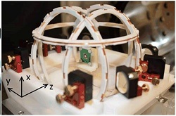
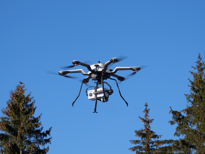
Airspace is a finite resource. Satellite navigation systems are critical to managing the skies for aerial vehicles such as commercial or military jets, small aircraft, helicopters, balloons and drones. If these systems fail, current navigation systems won’t be able to cope. What’s more, unmanned aerial vehicles such as drones and very light aircraft usually don’t have access to standard navigation systems’ equipment due to constraints in cost, size or power consumption. The EU-funded project NAVISAS(opens in new window) addressed how to provide APNT solutions to support small aircraft. “Current solutions comprise ground-based infrastructures transmitting non-satellite signals-in-space to avionics,” says project coordinator André Oliveira. “But these solutions cannot be used by small aircraft without major re-engineering of their avionic systems.” NAVISAS looked at merging multiple navigation solutions into a single package easy to integrate into the aircraft. It analysed several paths for technology mergers between satellite positioning systems (GPS and GALILEO), a miniature atomic clock (MAC), a miniature atomic gyroscope (MAG) and vision for applications in small aircraft navigation. New-fangled cost-efficient instrument The project envisions a merger of two different navigation systems on board the aircraft. This could be achieved by merging a Global Navigation Satellite System (GNSS) and an advanced inertial measurement unit (IMU) with specific innovations at the level of the gyroscope using microelectromechanical systems (MEMS) technology. This approach will provide a more pilot-friendly, flexible, reliable and accurate solution in a single device. “NAVISAS will pave the way for a new cost-effective instrument that can be used by small aircraft to ensure navigation performance levels consistent with evolving airspace and air traffic,” notes Oliveira. IMUs based on atomic gyroscopes and MEMS accelerometers are expected to become cheaper to manufacture. This means that the NAVISAS solution has the potential to replace current high-grade certified inertial systems using laser gyros. Experiments during the project confirmed that the NAVISAS solution would meet similar performance to laser gyros. This makes the solution more attractive to commercial aircraft manufacturers and opens the high-performance inertial systems market to smaller aircraft. “While there is still a long way to go before a mature and affordable atomic gyro is available, the envisioned performances are promising and could challenge the state-of-the-art laser ring gyros,” adds Oliveira. Vision element added Vision-based navigation, initially not in the scope of NAVISAS, was added to the study. A solution based on electro-optic cameras was tested in real flight and proved its usefulness for small aircraft, especially drones, as long as visual meteorological conditions are considered. Oliveira explains: “This is a very cheap alternative navigation method when compared to any other relevant system, able to provide APNT with very acceptable performance to continue the mission during GNSS outage.” Overall, the project resulted in the delivery of APNT operational concepts for small aircraft, approaches for the merger of GNSS receivers with MAC and atomic gyroscopes, and a proof of concept of vision-based navigation assessed in a drone’s actual flight. In addition, project partners carried out a feasibility study of the NAVISAS APNT. According to Oliveira, the consortium is seeking new opportunities that will enable NAVISAS technology to be further matured, with operation validation due in coming years. “If implemented, we believe the NAVISAS concept will also improve flight safety levels and contribute positively to performance and efficiency,” he concludes.