

JRC maps support Haiti rescue work
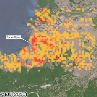
A preliminary damage assessment based on satellite images and published by the European Commission's Joint Research Centre (JRC) reveals that more than 4,000 buildings were damaged or destroyed in the Haitian earthquake on 12 January. The European Commission is helping to support relief efforts in Haiti in many ways. One important aspect of the EU's work in the disaster-stricken country is the generation of data and maps, which show that in Port-au-Prince, Haiti's capital city, and the nearby village of Carrefour, the 7.0 magnitude earthquake caused the collapse of about 2,000 residential buildings, government buildings, educational institutes and hospitals. The maps, which reveal extensive damage and destruction in the city, are based on the analysis of high-resolution satellite imagery of Port-au-Prince both before and after the earthquake. Since satellite images do not show internal damage to buildings, the levels of damage revealed in the maps are most likely underestimations. Rapid damage assessments provide valuable information to help governments and rescue workers plan relief and reconstruction measures. Meanwhile, a research team led by Professor John McCloskey from the University of Ulster in the UK has just published a new study in the journal Nature Geoscience that calls on governments and non-governmental relief organisations to take advance action to save lives in the next earthquake rather than waiting until it occurs. 'We can't continue to refuse to accept the inevitable,' stated Professor McCloskey. 'Earthquakes happen, they kill people, they will kill more and more people if we don't organise ourselves properly. We must start now.' Professor McCloskey's research group analysed the earthquake that triggered the Boxing Day 2004 tsunami. His team alerted the world to the possibility of another earthquake in the Sumatra region of the Indian Ocean 10 days before one struck Padang in Indonesia in September 2009, killing 1,000. For a number of years, scientists have been warning of the possibility of an earthquake to the west of Sumatra as collisions between the Indian and Asian ocean plates over the past 200 years have been storing up enormous amounts of energy. 'It's just like a bow,' warned Professor McCloskey. 'For hundreds of years, the energy is stored as the two tectonic plates bend and deform. Then, in just a few seconds all this energy is released, generating a massive earthquake and sometimes flexing the seafloor to create a tsunami. All the indicators are pointing in the same direction for western Sumatra. Another massive earthquake is due there and could happen any day.' While admitting that science doesn't have all the answers, Professor McCloskey said that there is much that can be done to prepare for earthquakes. 'We know this earthquake is coming and we might have years or even decades to prepare for it,' he said. 'We must work urgently to prepare for it if we are not to witness again the awful scenes of children dying for want of a few stitches or a cast for a broken leg. The September Padang earthquake and the tragedy of Haiti underline the importance of preparation.'
Countries
Haiti, United Kingdom