Social media, crowdsourcing, and AI join forces to achieve near real-time event mapping
Global social media usage continues to increase. There are now approximately 3.2 billion users worldwide(opens in new window), meaning about 42 % of the population is using social media. Enhanced accessibility on mobile devices is a key driver. The EU-funded E2mC(opens in new window) project has developed a platform to exploit user-generated data, improving accuracy and resolution of near real-time event maps for numerous applications. Its platform currently enhances the emergency management service (EMS)(opens in new window) of the EU’s Copernicus Earth Observation Programme(opens in new window).
Putting crisis maps in focus
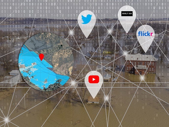
Near real-time and accurate information during the first hours of an unfolding disaster is critical to effective disaster management but current methods often lack the spatial and temporal resolution required. The E2mC project focused on developing a new EMS service component(opens in new window), the Copernicus Witness - Social&Crowd S&C platform(opens in new window), and an associated EMS product, a social crisis map. As project Technical Leader Domenico Grandoni explains, “The Copernicus Witness platform automates the collection, georeferencing(opens in new window), analysis, filtering, and visualisation of social media data. Social media crawlers collect data in 40 different languages from Twitter, YouTube, Flickr, and GDELT based on a set of keywords related to an event of interest. AI techniques tackle the main challenges related to social media data – filtering of irrelevant data and data quality improvement.” In addition, a group of volunteers(opens in new window), the ‘crowd’ component, is mobilised when the Copernicus EMS activation begins. These volunteers tag the content of images collected to enhance automated geolocation. The enhanced data is then used to create crisis maps that can be filtered using the tags.
From the test crowd to the Copernicus cloud and beyond
E2mC faced unique challenges posed by assimilating and meaningfully categorising a tremendously heterogeneous data set of relatively low quality, and in real-time. The team surpassed goals in many ways to do it with automatic filtering algorithms, an automated geolocation algorithm and AI helping to make order out of chaos. The platform has been activated during some 50 real events, 23 Copernicus-related. During those events, the system analysed relevant posts of varying density, from a few dozen in small forest fire events in Italy in July 2019 to more than 3 000 during the floods in Iran in March 2019. Other uses include monitoring of refugees and the humanitarian crisis, worldwide flood monitoring, boat accident tracking, and disaster monitoring that did not require Copernicus activation. Thanks to the close working relationship between the AI and crowdsourcing communities fostered by E2mC, new opportunities for collaborative research and development continue to arise. The platform has been eagerly welcomed by potential end-users in numerous fields, many of whom have noted the maturity of the system and its many functionalities. As Grandoni explains, “The most exciting part of the project is that now the platform, borne as a research project, is becoming operational. The outcome represents a real enhancement of the Copernicus EMS products.” Expect the S&C platform to continue to evolve. Pre-operational use is free and helps to validate use scenarios – so get onboard and support your community today.