A potential new tool for Copernicus: A European Coastal Flood Awareness System
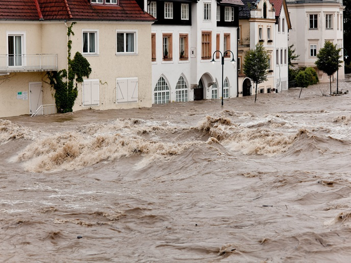
The Copernicus Programme - the EU Earth Observation and monitoring programme - is a cornerstone of the European Union’s efforts to monitor the Earth and its ecosystems, whilst ensuring that citizens are prepared and protected in the face of crises and natural and man-made disasters. The fundamental pillar of the Copernicus Programme are six cross cutting thematic services, namely Land Monitoring, Marine Environment, Atmosphere, Climate Change, Emergency Management and Security. January 2021 saw the launch of development of a new coastal flood awareness system that could become a candidate to join the Copernicus suite of services. This new system could contribute to the Copernicus Emergency Management Service (CEMS) by demonstrating the feasibility of a European Coastal Flood Awareness System (ECFAS) that will complement the existing framework for large trans-national river systems (EFAS). ECFAS will also develop innovative solutions for providing rapid mapping of forecasted flooding and will benefit from the integration of space research with other non-space domains, like oceanographic modelling and coastal risk assessment. Last year, several storms affected European coastlines, from the North Sea to Mediterranean countries. Storms Gloria, Ciara, Dennis and Brendan caused significant damage, extensive flooding and the erosion of coastal areas across Europe, from the Mediterranean to the Northern Atlantic and the North Sea. The Ebro Delta in Spain suffered flooding up to 3 km from the coastline with 30 square kilometers of rice fields destroyed and causing an estimated loss to the national economy of several million euros. This impressive sequence of disasters highlighted the urgency of implementing an operational system at the European scale, able to provide useful and timely information on coastal flood risk from extreme sea level events, for preparedness, response and recovery purposes. “Being prepared for the impact of coastal storms is of utmost importance. ECFAS represents a step forward to reach this goal” – Dr. Clara Armaroli, ECFAS Coordinator, Istituto Universitario di Studi Superiori IUSS di Pavia. ECFAS will provide a much-needed solution to bolster coastal resilience to climate risk and reduce population and infrastructure exposure by monitoring and supporting disaster preparedness, two factors that are fundamental to damage prevention and recovery if a storm hits. ECFAS will provide a “Proof of Concept” to demonstrate the practical feasibility of a coastal flood awareness system. Through a series of test cases (case study sites), ECFAS will build on existing tools from the Copernicus compendium, customizing them for applications in the coastal zone at pan-European scale. The ECFAS Proof-of-Concept development will run from January 2021-December 2022. The ECFAS project is a collaboration between Istituto Universitario di Studi Superiori IUSS di Pavia (Italy, ECFAS Coordinator), Mercator Ocean International (France), Planetek Hellas (Greece), Collecte Localisation Satellites (France), Consorzio Futuro in Ricerca (Italy), Universitat Politecnica de Valencia (Spain), University of the Aegean (Greece), and EurOcean (Portugal), and is funded by the European Commission H2020 Framework Programme within the call LC-SPACE-18-EO-2020 - Copernicus evolution: research activities in support of the evolution of the Copernicus services. For further information, please contact ecfas.project@gmail.com, ecfas.eu (ecfas.eu) (coming soon) or visit the Cordis website.