Combining technologies to give advanced warning of landslides
Landslides can directly affect the general population, for example, when urban areas are impacted or when infrastructure such as a bridge shifts its position due to ground movement. To avoid disasters and the consequent loss of life, it is vital to continuously monitor the motion of landslides and alert the local inhabitants and infrastructure operators when such motion exceeds given thresholds. The EU-funded GIMS(opens in new window) project developed an advanced, low-cost system for monitoring landslides and subsidence that integrates the Galileo(opens in new window) European global navigation satellite system (GNSS), the Copernicus(opens in new window) synthetic aperture radar (SAR) and inertial measurement units(opens in new window) (IMUs). “Their integration provides a better understanding of the monitored processes and a wider knowledge of the deformation phenomenon than if the technologies had been employed separately,” states project coordinator Eugenio Realini.
Satellites detect movement
The Copernicus Sentinel satellites periodically transmit radar data that can provide land deformation images once processed. The GNSS gives continuous measurements on given points collected by the Galileo satellites with millimetre accuracy. Finally, IMUs, also referred to as accelerometers, can detect tilting and motion in landslide areas to give real time alerts in case of sudden motions. Key technologies developed by GIMS include cost-effective antennas and receivers capable of tracking dual-frequency Galileo GNSS signals. In addition, a compact active transponder (CAT) supports SAR measurements by facilitating the ‘rerouting’ of the Sentinel SAR signal back to the satellite that transmitted it. This is useful when monitoring an area where there are few or no available natural reflectors to facilitate the detection of specific points to be measured. Each GIMS station supports software for processing GNSS, SAR and IMU data, with researchers having created innovative algorithms and software for integrating GNSS and SAR. According to Realini: “The key results for us have been to advance our GNSS processing capabilities and develop an innovative procedure to integrate GNSS and SAR measurements to exploit the synergy between these two technologies.”
Advanced warning protects people and property
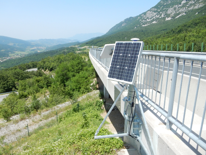
Project partners built, deployed and tested 14 GIMS stations at two landslide sites in Slovenia. The light and fully autonomous stations are powered by solar panels and can be easily installed on infrastructure, such as bridges located at the landslide site. “The early warning / alarm system and the accuracy of the data produced ensure that landslide related risks are mitigated, and crisis situations are managed effectively,” notes Realini. GIMS software receives GNSS and accelerometer data from the stations through the internet. It also receives the SAR data of the area covered by the stations directly from the European Space Agency Copernicus Sentinel servers. All these raw data are then processed to obtain land deformation results and compile a report for stakeholders, such as the public authorities and civil protection agencies. GIMS opened the way to the combined utilisation of the cost effective versions of three technologies often used separately: GNSS, SAR and IMUs. “Thanks to GIMS results, it is now possible to monitor more areas and with a higher number of stations. This allows for a more widespread, detailed and efficient understanding of the movements of landslides and their effects on structures to mitigate casualties and injuries and better plan maintenance intervention,” Realini concludes.