Powerful tool surveys water depth in shallow waters from space
Understanding the shallow bathymetry and morphology of our seas is crucial for marine and coastal management. This knowledge is essential for activities such as reporting for the EC’s maritime directive, coastal engineering and planning activities – all integral parts of the blue economy(opens in new window). Digital data on seabed characteristics greatly aids operations such as shallow-water dredging, sand reclamation and navigation. Furthermore, the euphotic zone in these shallow waters, which houses critical habitats, plays a significant role in biodiversity, carbon storage and coastal protection. Mapping and monitoring of these shallow water zones currently rely on cost-intensive boat or airborne surveys, diving transects or drop-down cameras. However, these methods are limited by budget constraints and cannot provide continuous and objective monitoring.
Heralding a new era of aquatic data collection
“We are optimistic that modern satellite capabilities and aquatic Earth observation (EO) analysis could significantly improve our current approach to data collection on shallow water morphology and habitats,” notes Kim Knauer, coordinator of the EU-funded 4S(opens in new window) project. Partners from seven countries collaborated, including EOMAP, Fugro, National Research Council of Italy, the Poseidon System, the county board of Västerbotten, the Portuguese Hydrographic Office, Maritime Software Solutions and Smith Warner International. “Data from the Copernicus SENTINEL-2 mission(opens in new window), recent advances in physics-based modelling of aquatic EO, machine learning and new EO archiving and processing centres form the core of our newly developed solution,” adds Knauer. “Our team at EOMAP(opens in new window) has already mapped parts of the German Baltic seafloor habitats and the Great Barrier Reef in Australia. However, we need to further improve algorithm accuracy, reduce manual interpretation, generate operational software solutions, and integrate big data from current EO missions.”
Technologies enabling accurate seafloor habitat mapping
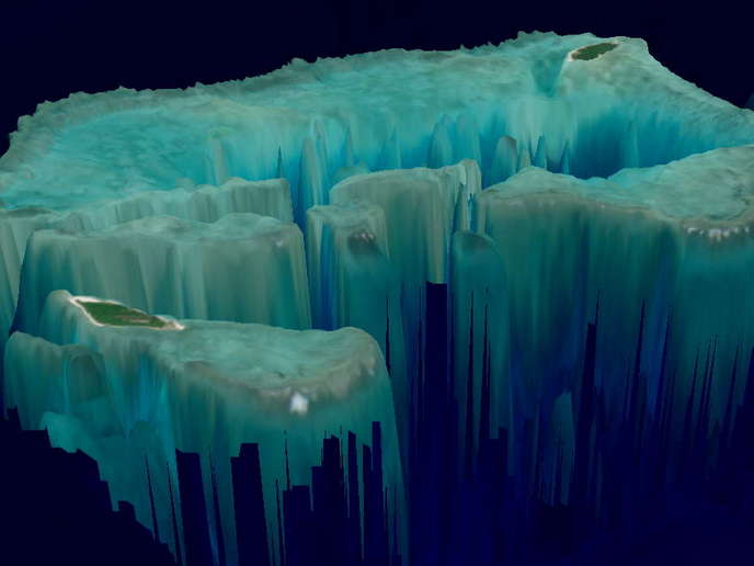
The 4S project sought to transform seafloor habitat mapping by bringing a higher level of automation and standardisation. “The 4S solution(opens in new window) is a user-friendly cloud-based software that enables users to map and monitor shallow coastal waters from their offices. Importantly, it can be integrated seamlessly into existing workflows,” highlights Knauer. A crucial initial step was the image selection approach, where an AI processor automatically predicts the usability of satellite image data based on cloud cover, sunglint and turbidity. The inversion of the radiative transfer equation – which is the analytical concept to calculate depth information – is directly coupled with the selected satellite imagery and installed on a cloud environment. That way, the solution is scalable while several hundreds of processes can be performed simultaneously. The algorithms also minimise signal distortions from the water and the atmosphere, producing a standardised reflectance product that accurately represents the seafloor. In addition, ICESat-2 Atlas Lidar bathymetry data was merged with multispectral data from Copernicus. This integration provided more accurate maps and significantly reduced product uncertainties. Ultimately, the team combined high-resolution drone imagery with satellite data, blending the centimetre-scale accuracy of drones and the multispectral band information from satellites. This resulted in highly detailed and precise maps.
Project impact
“We have successfully developed automatic routines to generate bathymetric point data from the active green LIDAR aboard the ICESat-2 satellite. Our web app SDB-Online generates dense shallow water bathymetric grids using physics-based satellite-derived bathymetry,” outlines Knauer. “This web app seamlessly integrates with the applications of our project partners and third-party users through application programming interfaces. In the course of the project, SDB-Online was relaunched to include new features such as a calibration/validation option with self-sourced field data.” Detailed validation analysis findings have been published in the peer-reviewed ‘International Hydrographic Review’(opens in new window). Each use case partner conducted further analyses using their own data and the results from SDB-Online. Overall, the feedback has been positive. However, some challenges arose in very turbid areas, where manual scene selection is crucial for deriving successful bathymetry. Project results were disseminated in several workshops and presentations, including the EOMAP-hosted SDB Days(opens in new window) in 2021 and 2022.