

Project Success Stories - EU research protects vulnerable communities from erupting volcanoes
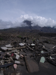
An eruption of Iceland's mighty Eyjafyallajokull volcano in April 2010 created a cloud of ash that closed many of Europe's airports, forcing more than 100 000 flights to be cancelled. Estimates reveal that across the globe 500 million people are at risk from volcanoes. In the European Union, anticipating and measuring the threat posed by volcanic activity depends upon the latest scientific knowledge and monitoring techniques. But in international cooperation partner countries (ICPC) risk management depends upon local conditions, which can be unfavourable. This is due to several factors, including local populations living on volcano slopes or possessing limited resources, such as monitoring equipment. A further challenge is presented by the long periods between eruptions when the volcano lies dormant, which can lull the population into a false sense of security with regard to the real threat. The 'Mitigate and assess risk from volcanic impact on terrain and human activities' (Miavita) project is determined to integrate more cost-effective methods for reducing risks from volcanic activity. Miavita means 'my life' in Italian and is a four-year project that addresses the multidisciplinary nature of volcanic threat assessment and management in ICPC and European volcanoes. The initiative builds upon recommendations from the UN's 'International strategy for disaster reduction' report, which covers such issues as prevention, crisis management and recovery. Although strategies are designed with ICPCs in mind they can also help European stakeholders expand their knowledge of volcanic risk management. Miavita has three main objectives. The first is to develop prevention tools based on risk mapping and identification of possible damage scenarios. The second is to improve crisis management capabilities through monitoring, early warning systems and secure communications. The third objective is to reduce the vulnerability of local communities and ecological systems and develop their ability to recover from a volcanic eruption. To reach these objectives, an integrated information system for organising and sharing data about the latest scientific and technological developments, and training is vital. Local know-how The Miavita consortium comprises a multidisciplinary team that includes civil defence agencies, national geological surveys, scientific teams and a private IT company.Local scientists and organisations in Africa (focused on Mount Cameroon, Fogo in Cape Verde) and Asia (on Merapi in Indonesia, and Kanlaon in Philippines) are closely involved in the risk assessment. These groups form an important part of the Miavita project thanks to their expertise in handling volcanic threats and their ability to respond to the entire disaster management cycle. Current activities include the installation of equipment at Fogo, Kanlaon and Mount Merapi and data acquisition coming from ground monitoring and remote sensing installations. The result has been a better understanding of the target volcanoes and their local areas. Workshops have been organised in Cape Verde, Indonesia and the Philippines for top officials such as ministers, governors, local authorities and heads of civil protection agencies. The workshops are intended to identify the stakeholders' needs and develop local authorities' awareness of managing risks occurring within the natural environment. According to Miavita's Coordinator Dr Pierre Thierry at BRGM, the French Geological Survey, the key to the initiative's success is the close cooperation among project partners. 'One example has been a training session on gas monitoring at Mount Merapi managed by Cambridge University for our partners from Indonesia. Its purpose was to teach how to perform ground-based gas measurements using differential optical absorption spectroscopy (DOAS) techniques,' he says. Collaboration between the two groups has proved particularly useful during the monitoring of the recent eruption of Merapi in October-November 2010. In addition, a partner from the French Civil Defence (DSC) has been to the Philippines to discuss crisis management with local institutions, stakeholders and representatives of the civil protection organisation. 'A similar mission is planned in the near future for Indonesia and will focus on the latest eruption at Merapi,' Dr Thierry reveals. Mount Merapi blows its top The Miavita project makes an important contribution to volcanic risk assessment and management, especially helping local people who have experienced recent events at Merapi. 'The eruption of the volcano during the course of a four-year research project is an extraordinary event. It is tragic considering the number of victims and displaced people, but it also represents an opportunity to make a step forward in our research,' says Dr Thierry. During the crisis, Dr Jousset (BRGM) and Dr Boichu (Cambridge University) joined the Indonesian team to help analyse data from the ground and satellite monitoring technologies. As soon as the information was received it was passed to the Indonesian partner organisation CVGHM to help assess and mitigate the eruption. Data, together with results from the United States Geological Survey, were used to determine the volcano's level of activity. This is the first time that the international community has responded in such a large way to combine their efforts following a volcanic eruption. Large deposits of material from the Mount Merapi eruption have covered a wide area, increasing the potential for major lahars - extremely destructive mudflows formed from a mixture of water and volcanic ash. Prof. Lavigne (University Paris La Sorbonne) is also collaborating with Indonesian partners to identify potential danger zones that are at risk of inundation from future lahars, which are a major risk during the monsoon period. Furthermore, following the main eruptions, new equipment has been set up to help rebuild a high standard broadband seismological monitoring network. Today the alert level of the area surrounding Mount Merapi has decreased to 2 on 4 and local partners are assessing damage to buildings, soil and agriculture. French and Italian civil protection agencies are expected to visit the region in the near future to share their experience of crisis management with local counterparts. Project partners are developing guidelines for multi-hazard and risk-mapping on active volcanoes. They have also developed and tested new methods for monitoring volcanoes, through the integrated use of remote sensing and geophysics techniques including gas, seismicity and ground deformation. Vulnerability of soils and agricultural systems to eruptions is being studied in-depth for the first time in Europe and guidelines for the integration of socio-economic aspects in risk management should be provided, including community based disaster risk-management plans. Plans for emergency communications systems in isolated areas have been launched and a book on volcanic threat assessment and management, created for decision-makers, scientists and stakeholders, is planned for 2012. Miavita has worked closely with local partners to enable scientists to gain a better understanding of the threat posed by volcanoes. More importantly, however, has been the achievement of improved safety for those communities living in the shadow of one of nature's greatest threats. Results of this major collaboration on the Merapi eruption will be presented to the scientific community at the next European Geosciences Union congress (EGU) in April 2011. The Miavita project is funded by the European Commission's Seventh Framework Programme (FP7) under the 'Environment' research theme.