Measuring Iceland’s icecaps
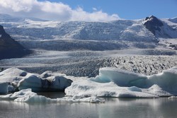
The ICEVOLUME (Ice volume changes of Icelandic ice caps in the last 75 years - a view from the air) project was established to produce a 3D view of Icelandic ice cap volume changes over the last 75 years. Researchers interpreted the causes of detected ice cap changes by co-analysing existing meteorological data, glacier surge records, ice margin records measurements and other datasets. A unique collection of aerial photographs and new light detection and ranging (LIDAR) DEMs provided the raw data for DEM production. Difference DEMs (dDEMS) were produced in geographical information systems (GIS) and analysed together with geometrically corrected aerial images (orthophotographs), which revealed glacier changes. Metadata for all the aerial photographs used for stereophotogrammetry were collated in a database. This included the ground position of image midpoints, flight heading and altitude, together with camera information and calibration. DEMs were produced from aerial photographs of a number of Icelandic glaciers and ice caps and from Aster satellite data. In addition, dDEMs were produced from the north margin of Vatnajökull, the largest ice cap in Iceland, for the years 1961, 1988 and 2003, and quantified the impact of a major glacier surge on the forefield. This represented an innovative approach for the quantification of changes in ice volume and sediment volume. Researchers also used the DEMs of Drangajökull, Iceland’s northernmost glacier, to quantify the volume of ice displaced during three glacier surges. Results revealed how the ice cap builds up again after surges and the surged ice volumes melt out during periods of inactivity. ICEVOLUME provides a significant advance on current understanding, which is mainly based on ice-marginal measurements and point measurements of ablation and accumulation. Understanding and quantifying recent glacier changes is crucial to being able to predict future responses of glaciers to a changing climate and environment.