

Where does the carbon go?
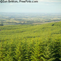
Increasing our understanding of how much carbon dioxide Europe's terrestrial ecosystems absorb from the atmosphere is the goal of a huge, EU-funded experiment taking place in south-west France throughout April. If humanity is to effectively combat climate change, it is vital that we know what is releasing CO2 into the atmosphere and what is removing it from the atmosphere. Plants absorb CO2 by photosynthesis, and release it, as we do, during respiration. Globally, land plants and other terrestrial photosynthesisers take up around a third of the CO2 emissions from fossil fuels, thereby slowing climate change. However, questions remain as to which vegetation types absorb the most CO2 and how these plants will react to climate change. This last question is of political importance as the Kyoto protocol allows signatories to include carbon sinks in the terrestrial biosphere in their carbon budgets. The CarboEurope project, which is funded by the EU's Sixth Framework Programme, aims to understand and quantify the role of Europe's terrestrial ecosystems in managing the continent's carbon balance. 'We're trying to understand the variability and vulnerability of the carbon budget,' Professor Han Dolman of the Free University of Amsterdam, one of the project partners, told CORDIS News. One difficulty in creating large-scale maps of where carbon is emitted and absorbed is that they are based on the assumption that one measurement of CO2 concentration is representative of a large area. However, research shows that in fact CO2 concentration can vary widely over relatively small areas. This is where the current experiment comes in. A team of researchers, led by Han Dolman, is mapping in detail the CO2 flux of an area 300 km by 300 km in the Bordeaux region of France. They will then use this information to see how measurements can be upscaled to feed into larger scale models The experiment area comprises the 'Les Landes' forest, a large agricultural area and the city of Bordeaux. It was chosen due to its relatively homogeneous land cover, the presence of the ocean and the pre-existing databases and modelling experience of project partner the French Meteorological Research Centre at Toulouse. The scientists will take measurements at ground level, at the tops of high towers and from balloons and aeroplanes to see how the different vegetation types in the region determine the CO2 flux and also measure other factors such as wind speed, temperature and humidity at different localities. A previous experiment in the same area in 2005 demonstrated that CO2 concentrations can vary by 10-20 parts per million (ppm) over 200 km. This year the researchers will leave some instrumentation in place until a second major experiment which will take place in September, to gain a perspective of how the carbon flux changes over several months. In terms of how climate change might affect the CO2 flux of the continent, Professor Dolman notes that researchers had a good opportunity to study this during the heat wave that struck Europe in the summer of 2003. The results showed that as the temperatures rose, atmospheric carbon levels increased as the plants effectively shut down and stopped absorbing CO2. 'If increased warming leads to increased emissions from the biosphere, then we have a nasty positive feedback loop,' warns Professor Dolman.
Countries
France