

EU project to speed up fight against forest fires worldwide
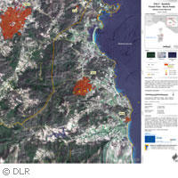
The recent forest fires in Portugal and northern Spain as well as the massive floods in Taiwan have highlighted the importance of responding quickly to natural disasters. The EU-funded project SAFER ('Services and applications for emergency response') is working to make this possible by providing rapid mapping of disaster-prone areas and other tools to help optimise disaster response. The project, financed with approximately EUR 27 million through the 'Space' Theme of the Seventh Framework Programme (FP7), is part of the larger Global Monitoring for Environment and Security (GMES) programme. Forest fires take a significant toll on the lives of citizens, and nature and wildlife in the EU and - due in part to the effects of climate change - appear to be increasing annually. Worldwide, vast areas of the globe are laid to waste by both fire and flooding. Early-warning systems that make use of satellite technology are highly desirable, but it is also crucial that once a warning is issued, the response is quick and efficient. For large parts of the world, existing maps showing important infrastructure, such as roads, tracks or urban settlements, are very out of date; this can be a severe handicap for any emergency-response operation. Accurate maps are urgently needed to help fighters and other protection services on the ground in their rescue operations. Gathering mapping information manually would be incredibly difficult and time consuming. One of the many goals of the SAFER project, which combines the expertise of 55 partners (including the Joint Research Centre and several small and medium-sized enterprises, among others), is to use satellite and radar technology to compile an accurate database of maps that can be requested immediately once an emergency has been identified. Likewise, accurate imaging of disaster areas can also be difficult, particularly during fires when smoke obstructs the view. One of the technological objectives of the project is to make the most of radar and advanced imaging techniques to provide useful reference maps to be used during emergency response. While the three-year project is still in its pre-operational stage, SAFER partners have already got their feet wet by providing services during the fires in Sardinia, Italy in July and the May floods in Bangladesh that claimed the lives of some 80 people. SAFER provided reference maps during both of these events. The overall purpose of SAFER is to reinforce Europe's capacity to respond to fires, floods, earthquakes, volcanic eruptions, landslides and humanitarian crises. Building on the success of previous EU-funded projects, the partners aim to provide services not only during the emergency response phase but to create, refine and validate tools that will contribute to rehabilitation and reconstruction efforts as well as preparation for future events. SAFER is one of the first tangible results of the European GMES programme. The main goal of GMES is to monitor and better understand our environment and to contribute to security. It provides land, ocean and atmospheric data to inform decision makers on matters affecting climate change and citizen security. Its preoperational services were launched in 2008, and it is slated to move on to its operational phase in 2011.