

Environmental observations for the EU Green Deal
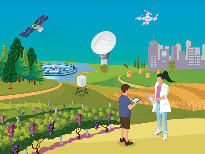
Research and innovation activities in this area provide practical solutions that have an effective impact in driving the transition to a resilient and climate-neutral economy and society, in line with the European Green Deal. Climate change, biodiversity loss and environmental degradation threaten our world. The European Green Deal(opens in new window) addresses these multifaceted challenges by setting out the path for transforming the EU into a circular, resource-efficient, climate-neutral yet competitive economy. The EU sets ambitious targets for addressing environmental challenges and realising their implementation with a series of legal instruments, for example the European Climate Law(opens in new window). Furthermore, the EU aims to decouple economic growth from resource use, reduce pollution and secure the supply of healthy food, while preserving biodiversity. Achieving these ambitious targets requires active participation and engagement from citizens, policymakers, and businesses alike. Moreover, the already-changing climate adds a level of complexity to this equation, as the environmental conditions and potential impacts of a decision are a moving target. To provide actionable information, we need data and models about the state and the evolution of the Earth system as a whole and its various parts such as urban centres, forests, or farmland. This is where environmental observations come in. This term refers to real-world data, measured or detected by sensors on the ground, in water, in the air or on satellites. Within this context, citizen science also plays a pivotal role in complementing observational systems run by authorities or researchers. By involving citizens, we not only gather valuable data, but also create a sense of ownership and responsibility towards our planet. The environmental data from all of these observations, together with socio-economic data and models, can provide user-tailored and actionable knowledge and insights referred to as ‘Earth intelligence’. Developing and scaling-up environmental observation applications towards Earth intelligence requires an integrated approach that combines the strengths of European researchers, developers and industry. The EuroGEO(opens in new window) initiative, the European regional initiative within the Group on Earth Observation (GEO), acts as an incubator to co-create solutions with users, such as businesses that need decision-support systems for improving the environmental and economic performance of their operations. The EuroGEO Secretariat(opens in new window) supports coordination and connects all actors including the private sector, facilitating mutual learning, the spreading of good practices and the development of successful business models for Earth intelligence applications in Europe. This CORDIS Results Pack showcases 11 Horizon research projects that provided tools and services tailored for businesses to master their green transition. The targets of the European Green Deal are supported by helping organisations to save energy, reduce emissions, safeguard biodiversity and by developing systemic solutions which provide multiple benefits, and future proof their operations against threats like wildfires or extreme weather events. The VITIGEOSS, NextLand and ENVISION projects integrated Copernicus(opens in new window) and Global Earth Observation System of Systems (GEOSS)(opens in new window) data with other sources and sensors to support sustainable agriculture and forestry. Forest fires are becoming more frequent and devastating due to increasing extreme drought conditions in many regions as a result of climate change. SAFERS developed a wildfire emergency management system that uses observation data from Copernicus and GEOSS, combined with data from social media, smoke detectors and mobile applications. ILIAD combined big data with advanced computing to create a digital twin of the ocean, which helps scientist to better understand and predict the impact of human activities and climate change. This work is directly linked to the European Digital Twin of the Ocean (European DTO)(opens in new window). SUSTUNTECH used research expertise, commercialised solutions and data provided by Earth observation satellite systems to make the tuna industry more sustainable. Air pollution is the greatest environmental health risk in Europe. CompAir, I-CHANGE and SOCIO-BEE worked with citizen scientists to monitor local air pollution and human behaviour in the face of a changing climate. HARMONIA created tools for predicting the impacts of climate change effects and enhance cities’ preparedness to respond to specific events like floods and dust storms. Finally, EIFFEL used advanced technologies to improve the quality and resolution of Earth observation satellite data and make it more accessible and applicable for everyone.