Medium-range flood forecasts
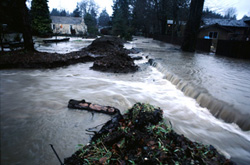
Changes in the global climate are becoming increasingly evident. The last decade has seen some of the wettest years on record across Europe in terms of precipitation. Severe flooding has resulted from several of these intense rainfall events. Flood forecasting relies heavily on reliable weather forecasts. Until not long ago, weather forecasts were only good for up to three days. Currently, forecasts of 7-10 days in advance are possible. The EU-funded EFFS project aimed to exploit these so-called medium-range forecasts in order to provide longer lead-times to public authorities dealing with potential flood events. EFFS brought together experts in meteorology and hydrology to solve this problem. As part of EFFS, the LISFLOOD model was enhanced with respect to the way in which it handles data. Apart from meteorological fields, such models also require information on elevation, land use type, soil type and antecedent soil moisture content throughout the model domain. Such data is increasingly provided in raster-GIS format, so LISFLOOD was designed to work directly with data in this format. LISFLOOD outputs the river discharge distribution, which can be used to determine the level of flood risk at various points downstream. Discharge refers to the volume of water passing through the river at a given point during a given time. Public officials and water management authorities can use this information to plan appropriate actions to mitigate flood risk. LISFLOOD is a general hydrological model and thus has other applications. Other uses include the analysis of changes in land use, climate and so on. The advantages of LISFLOOD over other existing models are twofold. One, the significant increase in lead-time from 3 days to 7-10 days will allow for more effective planning to reduce property damage and loss of life from flooding. Secondly, compatibility with the raster-GIS format greatly facilitates data assimilation and increases the pool of potential users. LISFLOOD's developers are looking to exploit these advantages in the marketplace.