Geo-information processing for landslide monitoring
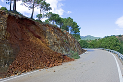
When locations for construction and their alternatives need to be chosen, the first step would be to recognise the existence of a landslide prone area. For accurately distinguishing landslide causes and activity, the detection of mass movements should however be based upon thorough geomorphological and geological investigations. OASYS, a multidisciplinary project funded within the Fifth Framework Programme aimed to collect as much information as possible for an advanced knowledge-based monitoring system. In a first step, remote sensing data had to be combined with geodetic deformation measurements carried out to detect surface traces of fractures and fault ruptures. High precision geotechnical measurement systems were then installed on the boundaries between stable and unstable areas. The multi-scale observation concept was successfully applied in the test area selected in North Western Greece, where landslide prone zones were reduced step by step. The Prinotopa landslide area, intersected by the Egnatia Motorway, is resurfaced due to snow melt and heavy rainfall every spring, as well as large earthquakes. The treatment of data from the heterogeneous geo-information systems (GIS) network with the SYSDeform software contributed decisively in the almost real time estimation of critical parameters. Because of the variety of factors contributing to mass movements, excessive volumes of data had to be analysed. Apart from the data collection and processing, the possibility of selecting different spatial analysis methodologies and implementing numerical models was provided by the custom-made software SYSDeform. Developed at the Aristotle University of Thessaloniki, it provided a variety of approaches for monitoring high-risk areas. The capabilities of SYSDeform reach further, from data capture and creation of natural hazards inventories to performing user-defined computations of landslide hazard maps.