Predicting landslides in the Alps
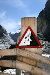
The varying cliffs, valleys, tilting plains and mountains of the Earth are known as hillslopes; here, large quantities of soil and sediments have been in constant motion over thousands of years. This movement process is called mass wasting and determines if the land is suitable for agriculture, building or other activity. The EU-funded 'Constraining geomorphic transport laws for mass wasting processes' (Slidelaws) project is investigating the concept of mass wasting. It is studying two drainage basins of the Trentino Region in the central Italian Alps, those of Val di Sole and Val di Fiemme. The project is examining the formerly glaciated landscape, including its hydro-geomorphology, bedrock, sediment flux and other characteristics that impact mass wasting. This is being achieved through a series of aerial photographs taken from 1954 to 2006, optical remote sensing technology (light detection and ranging or LiDAR), and laboratory experiments. The monitoring techniques have exposed the landslide characteristics of the regions and revealed how this land is used (e.g. alpine, pasture or forest), as well as topographic attributes (i.e. elevation and slope). When combined, these techniques are effective in understanding the frequency of landslides and their possible threats on settlement and agriculture, among others. To illustrate, the rate of landslide occurrence per unit area has helped calculate the intensity of the landsliding process. Another result from the Slidelaws project has highlighted clear lithologic and tectonic controls. High magnitude-low frequency events occur exclusively on metamorphic rocks. Events smaller than 300 000 m2 occur mostly on metamorphic slopes whereas sedimentary and intrusive lithologies are substantially less active. Again, this information can improve prediction and localisation of landslides. On the whole, this project is helping to advance our knowledge of landslide occurrence and outlining geomorphic transport laws. By identifying peculiarities in the geomorphology, slope characteristics and water flows, it will be possible to estimate the extent of potential landslides, including risk to infrastructures and residential areas.