Glacier dams and lakes
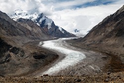
Natural piles of rubble, called moraines, block certain mountain rivers, thus forming lakes. Yet, under pressure from climate change, the glaciers are melting, more water is flowing into the lakes and the dams are in danger of bursting. The EU-funded DCGGEOPHYS (Subsurface conditions in Himalayan glaciers – Implications for outburst flood risk prediction) project helped assess risk of dam burst. The study addressed causes of lake expansion, and developed tools to investigate moraine subsurface properties. Researchers used new remote sensing and mapping methods, and took steps towards predictive models of dam burst. Work focused on the Norwegian islands of Svalbard plus the Ngozumpa Glacier in Nepal. For the latter, the team used a combination of stereo high-resolution satellite images, field mapping and lake sonar data. Thus, the team produced two digital elevation (3D landscape) models, showing glacial ice loss plus expansion and deepening of lakes. Researchers concluded that calving from exposed ice cliffs is the dominant form of glacial ice loss. Substantial melting also occurs within the glacier. The glacier drainage system plays a role in lake formation and expansion. Lake evolution is complex, driven in part by sediment deposition and reduced numbers of surrounding ice cliffs. The team further concluded that although 2009-2014 was a slow period of lake growth, rapid growth will resume in the near future. The lake may reach 7 km long if the moraine dam remains fixed. The team also developed geophysical tools for measuring subsurface properties of glaciers and moraine dams. They studied electrical resistance tomography and ground-penetrating radar. Hence, the group developed a more refined understanding of subsurface characteristics. Consortium members disseminated the results in a peer-reviewed journal and at conferences. Results offer a greater ability to predict the growth of glacial lakes and assess the dams' potential for failure. The outcome also means greater safety for communities living downstream from glacial dams.