

ESA fights forest fires
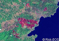
The European Space Agency (ESA) is backing a new Earth observation project aimed at monitoring European forest fire damage and identifying the areas most vulnerable to future outbreaks. As part of a joint ESA-European Commission initiative to establish an independent European capacity for environmental monitoring, the project will establish a standardised European method of recording fire damage and enable the sharing of information on forest fires and fire risks. In 2003, over half a million hectares of woodland were ruined by forest fires across Mediterranean Europe. According to European Commission estimates, every hectare of forest lost to fire costs the EU between 1,000 and 5,000 euro. Woodland fires tend to burn with a core heat of almost 800 degrees Celsius, bringing rapid and devastating changes to the landscape. The fires then leave 'burn scars' that can be seen from space as a 'specific reddish-brown spectral signature' explains ESA in a statement. The project will therefore employ satellite imagery to detect the burn scars within fire-prone regions of south-western France, the Puglia and March regions of Italy and the whole of Spain. At present, methods of recording devastation caused by fire differ greatly from country to country and even within regions. This new service, explains ESA, which is part of a portfolio of Earth observation services known as Risk-EOS, will develop a European-wide standard for burn scar mapping methodology. Furthermore, it will allow for a more precise 'post-fire damage assessment and analysis of vegetation re-growth and manmade changes within affected areas.' 'This will make possible a much more effective protection of the forest,' explained Nicolas Raffalli of the French 'Centre d'essais et de recherche de l'entente' (CEREN), the test and research centre of the organisation assigned with combating forest fires, and one of the partners in the project. Indeed, receiving even more details on the characteristics of the sites of past fires will enable service users to better forecast where fires are most likely to occur in the future. This process is known as risk-mapping. As ESA explains, 'overlaying burn scar maps with a chart of forest biomass has the potential to highlight zones where new blazes would burn the fiercest. Once such relatively fixed environmental elements, known as static risks, are factored in, other aspects that change across time - including temperature, rainfall and vegetation moisture - can be addressed. These variables are known as dynamic risks. At the end of the risk mapping process, the probability of fire breaking out in a particular place and time can be reliably calculated.' Thanks to this new information, it will be possible to set up preventative measures. The burn scar mapping system was started in 2003 and it is now hoped that further development in fire-related services will lead to even more new services by 2007. According to ESA, one planned service will be to 'identify 'hot spots' during fires, and map fire events twice a day, permitting an overall assessment of its development and the damage being done.' Another aim is to provide 'daily risk maps combining Earth observation with meteorological and vegetation data. And a 'fire memory atlas' will be set up at regional and national level to allow the routine sharing of all information relating to forest fire events and fire risk.'
Countries
Spain, France, Italy