

European researchers collect first seafloor images of tsunami earthquake zone
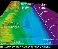
Researchers from the Southampton Oceanography Centre and the British Geological Survey have helped to collect the first seafloor images of the earthquake zone that caused the destructive Indian Ocean tsunami. The seabed images were collected by the UK Royal Navy's survey ship 'HMS Scott' using a high-resolution multi beam sonar. It is the first time that the seafloor has been surveyed so soon after an earthquake of this size, which measured 9 on the Richter scale. The results of the survey were more revealing that the scientists had hoped. The images clearly show the Indian Continental crustal plate colliding with the Burman plate at a depth of some 40 kilometres beneath the seafloor. According to a statement from the Southampton Oceanography Centre (SOC): 'The collision has resulted in the Indian plate being subducted (pushed underneath) the Burman plate, and it was a sudden movement of these two plates that led to the devastating earthquake and tsunami.' Coloured contour maps of the earthquake zone reveal how the collision has forced up spectacular ridges up to 1,500 metres high, and areas where these unstable masses have collapsed to produce large landslides. These initial findings will be used as the basis for further studies of the area as part of a wider international effort. The SOC's Lisa McNeill said: 'As a geologist I am really grateful for this opportunity to collect data across the earthquake zone. From this we hope to understand better the geological processes which produced the earthquake and ultimately help to determine future earthquake and tsunami hazards so that everyone can be aware and prepared.' Speed is of the essence in this type of survey, as it is vital to establish the degree of change that has occurred on the seabed before natural resettlement masks the true picture. It is hoped that this research will ultimately aid the establishment of an Indian Ocean tsunami warning system. Rebuilding the scientific capacity of the region affected by the tsunami is a priority after many nations' hydrographic resources were destroyed in the disaster. Work is already underway. For example, the UK, Norway, France and Germany are all collaborating to provide assistance to Sri Lanka in order to replace the country's hydrographic and survey capabilities.
Countries
United Kingdom