

French-US space mission to monitor sea level
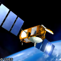
Work is underway on a new satellite to monitor rising sea levels and to study ocean circulation and its impact on the world's climate. The Jason 2-Ocean Surface Topography Mission (OSTM) is a joint effort between the French space agency (CNES), the European Organisation for the Exploitation of Meteorological Satellites (EUMETSAT), NASA and the US National Oceanic and Atmospheric Administration (NOAA). Running for a period of three years, the mission will provide scientists with data to monitor changes in global sea level and help them better understand how ocean circulation and climate change are related. The aim of the mission will be to add to the climate data record on global sea levels that was started in 1992 by CNES and NASA's TOPEX/Poseidon mission and continued with the Jason 1 mission in 2001. In its first month, the TOPEX/Poseidon mission provided more information about the height of the Earth's oceans than had been collected by ships during the entire previous century. Both these missions allowed scientists to chart the height of the seas across the ocean basins with unprecedented accuracy. Thanks to their work, we know that global sea levels have risen by three millimetres a year since 1993, twice the rate estimated by tidal gauges in the previous century. With the success of the TOPEX/Poseidon and Jason 1 missions, scientists have recognised the need to sustain these high-accuracy measurements into multiple decades to ensure that the data can be integrated into long-term climate predication models. 'OSTM/Jason 2 will help create the first multi-decadal global record for understanding the vital roles of the ocean in climate change,' said OSTM/Jason 2 project scientist Lee-Lueng Fu of NASA's Jet Propulsion Laboratory. 'Data from the new mission will allow us to continue monitoring global sea-level change, a field of study where current predictive models have a large degree of uncertainty.' Like TOPEX/Poseidon and Jason-1, Jason-2 will use a radar altimeter to measure the height of the sea surface. The altimeter sends a pulse of radar to the ocean's surface and times how long it takes for the signal to bounce back. A microwave radiometer then corrects any delay that may be caused by water vapour in the air below. Other corrections are made, taking into account the influence of electrons in the ionosphere - the uppermost part of the atmosphere - and the dry air mass of the atmosphere. Combining these data with the precise location of the satellite makes it possible to determine the sea level within a few centimetres. Several improvements have been made to the instruments on board Jason 2, which are expected to enable scientists to measure ocean coastal regions much more closely and to provide data to the forecasting agencies worldwide for short and seasonal-to-long range weather and climate predictions. 'What began as an investment by NASA and CNES in research tools for studying the ocean has matured into a proven technique that will now be routinely used by the world's weather and climate agencies to make better forecasts,' said Michael Freilich, director of the Earth Science Division in NASA's Science Mission Directorate. 'People in coastal areas will benefit from improved near-real-time data on ocean conditions, while people everywhere will benefit from better seasonal predictions resulting from the increased understanding of Earth system processes enabled by these measurements.' The OSTM/Jason 2, which is expected to ready for June, will fly in formation with the Jason 1 to provide simultaneous measurements over a period of six to nine months. The spacecraft will then continue Jason 1's former flight path, while Jason 1 will move into a parallel ground track midway between two ground tracks.
Countries
France, United States