

Geologists develop early warning system for avalanche events
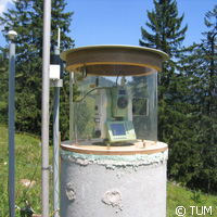
Hiking in the Alps or other alpine regions is one of life's greatest adventures but it can also be a dangerous experience as avalanche threats triggered by climatic changes are on the rise. While people monitor all endangered areas, it is not enough as manpower requirements and costs are high. But this is about to change thanks to a team of scientists from Germany that has developed an inexpensive system to monitor slopes, assess changes and provide early warnings to communities that are at risk of landslides. An outcome of the research project alpEWAS ('Early warning system for alpine slopes'), this new system, supported by various technologies, will help geologists better understand these natural phenomena by means of long-term measurements. Unstable masses of earth, found in the Alps and other alpine regions, have been in the research spotlight for some time. Geologists are paying particular attention to snowfall and heavy rainfall generated by climate change, which has led to the softening of the substrate and increased weight on it. Scientists do not have a hard time identifying which mountain slopes are safe and which are potentially dangerous. Several areas have been unstable for hundreds of years. Experts say the remains of previous slides point to prior disasters; records also reveal endangered slopes in alpine areas. Methods to detect movements include inserting probes into drilled pockets and measuring marked surface points. But the installation of such devices can burn large holes in people's pockets, forcing geologists to perform inspections at intervals and obtain much less information about what is happening inside the slope. This is where the geologists from Technische Universität München (TUM) and the Universität der Bundeswehr München (Bundeswehruniversität) enter the picture. They have made major progress in developing geo-sensors; they have also combined them with monitoring software into an early warning system that is both flexible and economical to deploy. When this system is triggered, safety experts could barricade the slope, re-direct traffic or evacuate buildings. Another upshot is that they can be drilled into the ground at various locations. 'We simply fill the drill pockets with basic coaxial cable, such as one uses for antenna cables, for example,' explains TUM Engineering Geology Chair Professor Kurosch Thuro. Under this system, if the surface mass of earth begins to slip, the cable will be crushed at the transfer point against the unmoving stratum. A small transmission device on the surface records this event and relays the information. Led by Professor Otto Heunecke, the Bundeswehruniversität team for its part distributes sensors whose position can be detected by Global Positioning System (GPS), over the slope. The geologists seek to obtain precise measurements using cost-efficient, ready-made components for recording movements, regardless if they are small or large. A video-tachometer, which is a new-generation measuring device, is also used. Encompassing both a laser scanner and camera, this device identifies natural target objects like stones and their movements. Citing the structure of a cliff as an example, the geologists say the tachometer charts and re-measures the structure at periodic intervals and records any changes. 'If we don't have to set up reflectors, we will save even more money,' TUM Geodesy Chair Professor Thomas A. Wunderlich says. 'And we do not have any more concerns about grazing cattle running over them.' Backed with these advanced components, the geologists set up a granular network of monitoring points across the slope; the data is collated at a central database. The system's 'brain' evaluates the information together with other parameters including weather data. The geologists are cooperating with industrial partners to develop the system requested by the German Federal Research Ministry and the German Research Foundation for commercialisation purposes. A number of groups have already expressed an interest in obtaining the system.For more information, please visit: alpEWAShttp://www.alpewas.de/Technische Universität München (TUM):http://portal.mytum.de/welcome/Universität der Bundeswehr München (Bundeswehruniversität):http://www.unibw.de/startseite/index_en.html
Countries
Germany