‘Extreme’ citizen science engages remote communities
Citizen science typically engages educated and tech-savvy members of the public to carry out defined tasks. While valuable for scientific literacy and gleaning information that might otherwise be hard to obtain, it can exclude some communities. The ECSAnVis(opens in new window) project, funded by the European Research Council(opens in new window), leveraged ‘extreme citizen science’ – a more bottom-up and inclusive approach, sensitive to local context. “We collaborate with people with limited literacy, on issues of concern to them, involving them in everything, from project design to use of results,” explains Muki Haklay, project coordinator. ECSAnVis established a methodology for working with indigenous groups which they tested across different cultural contexts, developing bespoke data collection software, as well as a prototype visualisation tool. “We demonstrated that, with appropriate support, any community, regardless of literacy, can participate in the production of scientific knowledge,” adds Haklay from University College London, which hosted the project. As well as publishing an open access book(opens in new window) – with thousands of global downloads – the project supported 25 early-career researchers.
Co-designing citizen science input for biodiversity
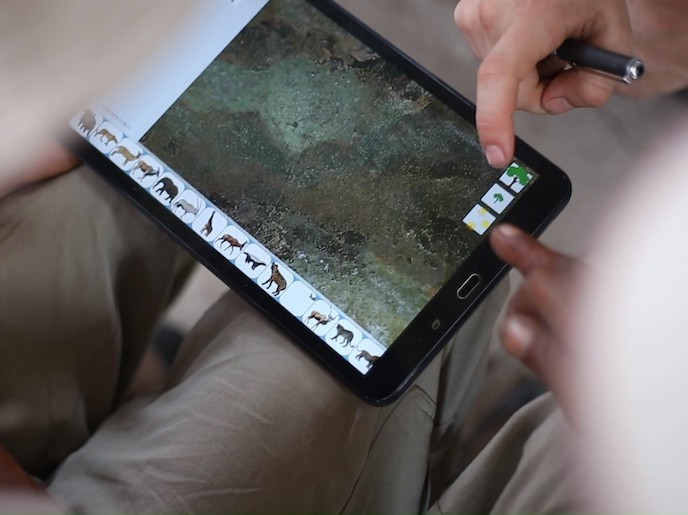
Once free and informed consent of a local community was granted, a community protocol for how to proceed was agreed. This was followed by the co-design of the pictograms and icons to be used by the project’s own open-source data collection app, Sapelli(opens in new window). Sapelli can collect data in areas without connectivity, but when connectivity becomes available, it transmits the data to a geographic information system(opens in new window), GeoKey(opens in new window), also developed by the project. This lets the team store, manage, analyse and present the data, as well as manipulate it for activities such as forecasting, or tailor it for specific audiences, such as indigenous groups. “Aside from actually using it to tackle issues of local concern, perhaps the most important stage is showing community members the data collected, using our visualisation prototype – the Sapelli Viewer,” says Haklay.
Cross-cultural communication to collect data
The team set up 20 case studies around the world. For example, they worked with the semi-literate Julʼhoan of Namibia. The Nyae Nyae Conservancy borders five countries and contains a wealth of protected fauna and flora. As custodians, the Julʼhoan used Sapelli to support their natural resource management activities(opens in new window), such as the monitoring of animal movements, poaching and illegal grazing. In the hugely biodiverse Brazilian Pantanal wetlands, local communities used Sapelli(opens in new window) to collect data about their fishing practices and local environment. This demonstrated that their traditional practices were sustainable and so should be protected by local conservation policies. “When combined with appropriate social processes, new technologies can help people communicate across linguistic and cultural barriers. “This helps participants collect data that can contribute to evidence-based decision-making. These tools can make the voices of the marginalised, heard, offering researchers the benefit of different perspectives,” he remarks.
Supporting key custodians
Thanks to the EU’s support for citizen science, ECSAnVis has demonstrated that including local populations is possible with any community, no matter how remote. “Our process can help monitor resources and supports more collaborative decision-making; crucial because many of these communities live in areas of rich biodiversity that need environmental protection,” says Haklay. The software is available as an open-source resource, alongside training material useful to other researchers. The team is now pursuing funding options to develop a package of tools as a not-for-profit product. Meanwhile they are planning additional case studies to continue and adapt their methodology to other contexts. “We are also considering how advances in machine learning and data science could improve applications, as well as how this information could more directly influence policymaking,” concludes Haklay.