Satellite data offers accurate marine algae surveillance
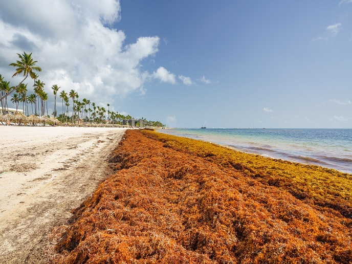
Since 2011, massive landings of Sargassum(opens in new window) have been reported in the Caribbean. These invasive blooms of algae can make marine navigation difficult, impact wildlife and foul offshore turbines. The algae also piles up on pristine tropical beaches, rotting with a bad stench. “Before 2011, there were no reported massive landings,” explains e-shape(opens in new window) project pilot leader Marion Sutton from CLS(opens in new window) in France. “One theory is that an anomaly in ocean circulation enabled Sargassum to escape from a region in the Atlantic called the Sargassum sea during the winter 2009-2010. The algae has since been oscillating with the currents between the Caribbean and West Africa.”
Seasonal forecasts of Sargassum
CLS has been working on the Sargassum algae issue since 2018, using satellite data to inform Caribbean marine coastal services and governments and help them to better monitor the situation. To this end, a dedicated tool(opens in new window) has been developed, providing end users with a 5-day forecast. “Our role in the e-shape project was to build on this,” says Sutton. “We wanted to go beyond the 5-day forecast, and provide tools that can facilitate seasonal planning.” To achieve this, the project team looked at historical data, and developed algorithms to interpret current satellite information. This work represented an important element of the overall e-shape project, which sought to improve user uptake of Earth observation data across a number of fields. “We used high-resolution data sourced from Copernicus Sentinel-3(opens in new window) satellites,” adds Sutton. “This data provided a resolution of 300 m, far better than current resolutions of 1 km.” The pilot project team also used data from Sentinel-2(opens in new window) satellites, which provided a resolution of just 20 m. This enabled the team to go into far more detail about the density and extent of the algae rafts.
Long-term forecasts enabling effective action
Throughout the project, Sutton and her team worked closely with end users in the Caribbean, including national marine parks. Satellite data was used to produce bulletins warning about possible algae influxes over the following six months. This enabled preparatory actions to be taken, and government support to be requested. The positive results have enabled CLS to refine their forecasting tools. A number of entities in the Caribbean are currently using these services, to better prepare for the arrival of Sargassum algae. “We are also sharing our data(opens in new window) with researchers,” notes Sutton. “There is a real need for operational data from the scientific community.”
Identifying commercial opportunities using Sargassum
Sutton and her team regard the e-shape project as an important milestone in using satellite data to protect the marine environment. Timely action means that pristine Caribbean mangroves and beaches, for example, can be better protected. There are also potential opportunities to valorise collected Sargassum, and turn it into products such as fertiliser, biomaterials, cosmetics and even animal feed. Sutton notes that a number of pilot projects in the Caribbean region are currently under way, to see if collected Sargassum could be used as a biofuel. “Many of these start-ups are at prototype level, and need information about seasonal influxes to prepare their business plans,” she explains. “This is where satellite information can help.” CLS is currently involved in a follow-up EU-funded project, called SODA(opens in new window). A key aim of this initiative is to develop new algorithms, and find ways of better sharing satellite data for marine purposes. Another project, called SeSaM(opens in new window), aims to strengthen seasonal forecasting. “These projects represent the next step forward,” says Sutton.