How do we map the bottom of the ocean?

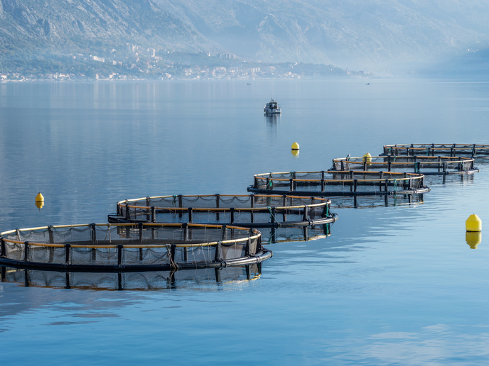
When it comes to mapping the Earth’s surface, the process is pretty straightforward: armed with some simple surveying tools, hike to a point and measure where it sits in relation to another point (or three). Keep doing that, and you’ll soon build an accurate picture of the land. Newer technologies – from drones to satellites – make this even easier. But what about the 70 % of the world that is covered by water? “Water significantly curtails our ability to survey, and requires the use of a lot of different technologies and techniques,” says Knut Hartmann, chief operating officer at EOMAP, a company that specialises in mapping and monitoring aquatic environments. One crucial tool for mapping the deep ocean is a boat. “Boats can emit sonar signals that ‘paint’ the ocean floor, creating a sound map that depicts such characteristics as depth and topographical features,” explains Hartmann. Although some surveying vessels are small and even autonomous, most vessels used for mapping the ocean floor are large. While ideal for mapping the expansive and deep oceans, this size prevents these same boats from being used to map the very shallow waters of coastal areas. “We tend to assume that the ocean is perfectly mapped, but it is not. In most coastal waters, even the shallow areas, which are important in many ways, are unmapped or unmonitored,” says Hartmann. Mapping shallow water areas can be done using a smaller boat, but doing so requires the vessel to zigzag back and forth over the entire area – a process that Hartmann says is time-consuming, expensive and “crazily complex”. A more practical approach to mapping shallow water areas is from the sky. Here, surveyors use airborne lasers, measuring how long it takes for the light to penetrate the water and reflect back. “It’s a pretty cool process, but requires a lot of high-tech equipment, meaning it isn’t always practical,” notes Hartmann. A third possibility is to use satellites. “Satellite sensors use different parts of the electromagnetic wave to make measurements, such as measuring the radiation that is emitted from the ocean’s surface or transmitting signals to the surface and then measuring the return signal that comes back,” adds Hartmann. Much of this satellite ‘raw’ data, including that provided by the EU’s Copernicus Earth observation programme, is freely available. It can also be used in synergy with other very high-resolution imagery, allowing for both a high-resolution map of the seabed and the ability to continuously repeat the process without the need for on-site equipment. Each technique has its own advantages and drawbacks, and most mapping campaigns use a variety of different techniques.
The need for mapping and monitoring
But why map the ocean floor at all? “Mapping gives us an up-to-date overview of the underwater topography and allows us to identify underwater habitats and resources and improve our ocean and coastal models – information that we don’t have for most of the seabed,” explains Hartmann. Creating a map is just the first step. “Monitoring, which involves continuous mapping, gives us a constant overview of an area and allows us to detect changes, which is more important than ever in times of climate change and natural and man-made pressures on the environment,” adds Hartmann. Having accurate maps is also essential for the building and maintenance of infrastructure such as offshore wind farms and deep-sea cables. Maps can also play a critical role in managing and mitigating natural disasters, such as coastal flooding and tsunamis. But while we have the will and the way to do underwater mapping and monitoring, there’s still a long road ahead. To date we’ve only mapped 25 % of the ocean floor, and only a fraction is frequently monitored. Thanks to always advancing technologies and global initiatives such as Seabed 2030 and the EU-funded 4S project, Hartmann is confident that we will not only successfully help map the ocean’s floors, but do so in increasingly detailed resolution and with more advanced monitoring capabilities. Click here to find out more about Hartmann’s research: Powerful tool surveys water depth in shallow waters from space.