

ESA tracks Hurricane Dean
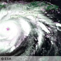
Two European Space Agency (ESA) satellites have been tracking the path of Hurricane Dean as it swept across the Caribbean and Mexico, providing timely warnings for emergency rescue services. The satellites, Envisat and ERS-2, are deploying their Earth observation instruments to gather information on the forces powering the storm, including wind and wave fields and sea surface temperatures. These optical and radar instruments enable the researchers to observe high-atmosphere cloud structure and pressure in the visible and infrared spectrum. The Medium Resolution Imaging Spectrometer (MERIS) optical instrument displays the swirling cloud-tops of a hurricane. Meanwhile radar instruments, such as the Advanced Synthetic Aperture Radar (ASAR), pierce through clouds to show how the wind is shaping the sea surface, and estimate how destructive the storm is likely to be. One especially valuable tool aboard the ERS-2 satellite is the radar scatterometer, employed to observe the hurricane's underlying wind fields. The scatterometer instrument works by firing a trio of high-frequency radar beams down to the ocean, then analysing the pattern of backscatter or radar echo reflected upwards. Thanks to its use of C-band radar frequency it can return useful wind data even from the heart of the fiercest storms. 'Observed winds from hurricane Dean by ESA's ERS-2 scatterometer are provided to meteorologists within the hour. This C-band radar wavelength scatterometer peeks right into the 'eye' of a hurricane like Dean, providing timely and precise information on its position and force,' explains Dr Ad Stoffelen of the Royal Netherlands Meteorological Institute (KNMI), which processes ESA's scatterometer images. 'The wind fields derived from the ESA ERS-2 scatterometer measurements are distributed via a EUMETSAT [European Organisation for the Exploitation of Meteorological Satellites] project to a registered database of a few hundred users, originating from all over the world, including the Americas, Australia, Asia and Europe. Scatterometer winds are used directly by shift meteorologists in forecast rooms and to initialise Numerical Weather Prediction models aiding the forecasting of hurricanes five days ahead,' Dr Stoffelen added. Another instrument aboard the Envisat, Radar Altimeter-2 (RA-2), uses radar pulses to measure sea surface height down to an accuracy of a few centimetres. Near-real time radar altimetry is a powerful tool for monitoring a hurricane's progress and predicting its potential impact. Water temperatures are the main underlying energy reservoir that power hurricanes; together with the correct atmospheric conditions, temperatures need to exceed 26°C in order to form and maintain a tropical cyclone. Because warm water expands, scientists can locate warm underwater ocean features by detecting bulges in the ocean surface height, as detected by RA-2. Both ESA and the US National Oceanic and Atmospheric Administration (NOAA) are collaborating by using Envisat RA-2 results, along with those from other space-borne altimeters, to chart tropical cyclone heat potential (TCHP) and improve the accuracy of hurricane forecasting. As predicted by ESA, Hurricane Dean struck Mexico's Yucatan Peninsula and Belize on 21 August. Classified as a Category Five hurricane, with winds reaching as high as 260 km/h, it had already claimed 12 lives by 22 August.