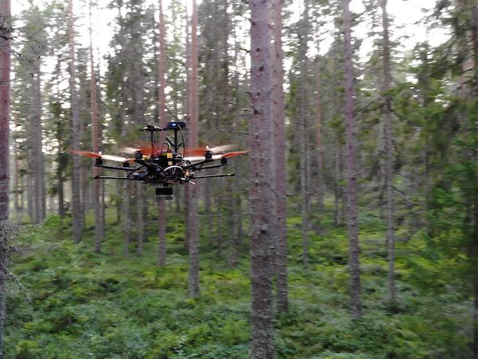
If a tree falls in the forest, these drones will spot it
The EU has around 5 % of the world’s forests, some 183 million hectares, and thanks to strong stewardship, the forested area in the EU is increasing(opens in new window). But managing these stands is labour-intensive and prone to error, a situation the DFD project hopes to change.
Digital twin
“It came about as I was listening to friends who were forest owners, they were frustrated that timber estimates were inaccurate,” says Levi Farrand, DFD project coordinator. “I thought: this can be done mathematically.” Typically, timber estimates are made by forestry fieldworkers, who base these figures on visits to around 10 % of the stand. Farrand’s solution is a novel drone type that flies into the forest, underneath the canopy, autonomously navigating between the trees carrying lidar(opens in new window) equipment that can generate a map of the forest. “It’s not financially feasible for humans to map the whole forest, that would mean literally marking every tree on a map,” explains Farrand. “We provide a new tool to forestry fieldworkers that will enable them to create digital twins of entire forests in three dimensions.”
Contextual info
Farrand’s start-up Deep Forestry(opens in new window) exploits remote sensing technology that has become available through the rise of autonomous vehicles. “The technology hasn’t been available until now, we have been working on this a few years in the expectation the technology would arrive,” he notes. With support from the EU Horizon 2020 programme, Farrand was able to carry out essential business development work. “We spent a lot of time meeting with companies personally, that was a massive help and we solidified our pricing, which is a very difficult thing to do,” adds Farrand. As well as generating 3D maps of forests, Deep Forestry has produced a 3D machine learning algorithm to interpret the resulting data. This will not only make estimates of the available timber and identify where it is growing best, but also provide contextual information to commercial harvesters.
Data bottleneck
“We can say ‘there are some protected species here’, or ‘look out for this boggy area, don’t drive a harvester over it as this will damage the harvester and the ecosystem’,” explains Farrand. “So there is this sustainability aspect to it.” The drone surveys can also be used to validate satellite imagery with ground truth data, expanding the reach of the new drones’ insights on a global scale. Farrand stresses that the goal is not to replace the human workers: “With our drones, every fieldworker in the EU will be able to gather 5-10 hectares of 3D data every day. We’re breaking open a historical data bottleneck." The data gathered by the drones will make each fieldworker more valuable to the forestry companies, empowering the industry throughout the entire value chain. Next, Deep Forestry intends to apply for phase two funding to advance the company. “We’ve finished tech development, the prototype works, we have tested it in the field, with paying customers, but that prototype is made of sticky tape and cable ties,” he says. His immediate goal therefore is to move from prototype to product, and shift from selling the drone surveys as individual demonstrative pilot projects to a globally scalable per-hectare billing system.