Geodata delivers tools for sub-Saharan Africa
Sub-Saharan Africa is grossly underserved when it comes to in situ observation(opens in new window) networks. This can limit the accuracy of services such as weather forecasting and water management, and negatively impact critical sectors such as agriculture. “Although satellites are powerful sources of information, they tend to be inaccurate when not used in conjunction with on-the-ground measurements such as river flows, rainfall and soil moisture,” explains TWIGA(opens in new window) project coordinator Nick van de Giesen from Delft University of Technology(opens in new window) in the Netherlands. “For a geoinformation(opens in new window) service like a flood early warning system, for example, you need at least some stations on the ground, to make sure you have the right initial conditions for your forecasts.”
Geoservices for local communities
The EU-funded TWIGA project sought to address this technological gap by facilitating the development of geoservices for communities in sub-Saharan Africa. A key objective was to involve local stakeholders such as farmers as much as possible and ensure that tailored services would continue to serve communities after project completion. “We started out with a long list of possible geoservices and in situ sensors,” says van de Giesen. “We evaluated their technical and market feasibility, and then sought to integrate the most promising technologies by combining them with satellite data and computer models.” Innovative new sensors include neutron counters for soil moisture measurements, and very simple raindrop counters. “The pathway from an innovative new sensor idea to an application that pays for itself takes a long time to build,” explains van de Giesen. “So the shorter the chain, the better the chance of success.”
Sensory data platform
To achieve this, the project team set about building the TWIGA platform. This is the centrepiece of the project, gathering satellite and sensor data and making this information freely available to users. The platform is accessible via an online portal(opens in new window), and users can create their own custom dashboards tailored to their own needs. The project team has also built ready-made dashboards, enabling new users to easily interact with data without the need for detailed knowledge. Out of this work, a number of tailored services have been developed. These continue to be used by farmers and other stakeholders.
Crop alerts and flood warnings
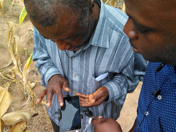
Farmers for example can receive alerts on their mobiles as to how wet their soil is, helping them to decide when irrigation is needed and when spraying for certain diseases is needed. Drones can also be used to unobtrusively inspect fields and inform farmers about crop status, allowing them to detect changes that cannot be readily identified at the ground level. “Scientists, including applied scientists in the hydrological and meteorological services in different African countries, also stand to benefit from better observations of water and weather variables,” adds van de Giesen. “We developed important information services, such as the flood early warning system for the town of Narok in south-western Kenya.” In other countries such as South Africa, where drought is very common, insight into water availability is crucial for water managers, enabling them to anticipate water scarcity. Moving forward, the project team intends to continue further developing innovations pioneered through the TWIGA project. “The reservoir information system, which was developed for South Africa, will be expanded to other African countries, such as Ghana,” says van de Giesen.