Data-driven insights on the risks of rising sea levels
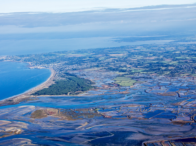
According to the Sixth Assessment Report of the Intergovernmental Panel on Climate Change(opens in new window) (IPCC), sea levels will likely rise between 0.3 m and 1 m by 2100 and will continue to rise for centuries thereafter, and only an immediate and massive reduction in greenhouse gas emissions will stop further acceleration of sea level rise. The coastal flooding that such a rise will trigger has the potential to wreak havoc on the many cities, businesses and infrastructure located close to Europe’s shorelines or in low-lying areas. “As we are committed to decades and centuries of sea level rise, it is important to understand what is at risk,” adds Le Cozannet. Helping to deliver that understanding is the EU-funded CoCliCo(opens in new window) project.
An open-source web platform for coastal risk management
CoCliCo is an open-source web platform(opens in new window) designed to improve decision-making on coastal risk management and adaptation. “Built for policymakers, planners, infrastructure managers and researchers, CoCliCo provides high-resolution sea level rise projections, flood hazard assessments, exposure analysis, and cost-benefit comparisons of adaptation strategies,” explains Le Cozannet, who served as the project coordinator. What’s more, all this information is provided in an intuitive map-based interface and backed by open, authoritative datasets. This makes it particularly easy for users to explore future coastal hazard scenarios, assess flood and erosion risk exposure for specific populations and infrastructure, and compare adaptation options through cost-benefit analysis. The platform also features ready-made user stories to help visualise impacts and solutions. “Whether you’re working on national flood directives, designing resilient urban plans or advising on climate policy, CoCliCo can be useful for you,” notes Le Cozannet.
A climate service capable of supporting coastal adaptation
Although CoCliCo is not perfect, Le Cozannet says it does demonstrate that a climate service supporting coastal adaptation in Europe is feasible. For example, while the platform is already able to help in many areas relevant to coastal adaptation, it lacks the ability to predict the projected costs of coastal flooding precisely – which are very much dependent on the choices that are made on coastal adaptation. “That being said, I am confident that the platform will help us understand these uncertainties and how the adaptation choices we make today could become vulnerable to future coastal conditions,” remarks Le Cozannet. The project team is currently working to advance the platform from its demonstrator status into a fully operational climate service. Thanks to the support of project partner Mercator Ocean(opens in new window), the platform is also being integrated into the Copernicus Marine Service’s(opens in new window) Digital Twin of the Ocean project. The CoCliCo team has published a policy brief(opens in new window) outlining its plans for the future development of the platform, as well as a position letter calling on European leaders to support science-based decision-making. “CoCliCo is a case study in how scientific data can not only help drive climate smart decision-making but also strengthen European cohesion and sovereignty by increasing its resilience,” concludes Le Cozannet.