Seismic Vulnerability and risk assessment
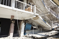
Throughout history, earthquakes in populated areas have caused tremendous damage. Today, the built environment and populations are larger and so is their exposure to seismic hazard. Knowing what the expected risk in future earthquakes is, makes it possible to plan efficient mitigation strategies. The SYNER-G(opens in new window) project focused on the comprehensive analysis of seismic vulnerability and risk assessment of complex urban or regional systems, and considered the potential interactions between systems, which normally increase the seismic losses. The 14-member consortium comprised mostly of European partners and one agency each from Japan and the United States. The project received EUR 3.5 million in EU funding to study the seismic risk to buildings, transportation and utility networks and critical facilities. The project developed a general methodology, including the scientific basis for vulnerability and loss assessment accounting for all relevant uncertainties and modeling interactions between the multiple component systems. The work included defining all elements at risk (taxonomy, typology) and proposed means of data interpretation, which were incorporated into a prototype open source software system. Other work included modelling of appropriate seismic hazard parameters (intensity measures), and methods of extracting key information about urban infrastructure from remote sensing and other spatial data. The project also studied socioeconomic vulnerability and losses estimates, proposing adequate methods and indicators of coping capacity and impact. For example an indicator was proposed to capture post-disaster emergency shelter demand decisions. Similar modeling included studies of casualty estimation, accessibility features and hospital functionality. Project partners validated their models and tools at selected test sites. These included urban areas (Thessaloniki and Vienna), regional networks in Italy (i.e. a gas network in L’Aquila), and complex systems such as Thessaloniki's harbor and an Italian hospital. The project's investigators provided averaged mathematical estimates of the network's performance, plus maps showing the distribution of estimated damages. SYNER-G's software tool was made publicly available and, supplemented with a comprehensive tutorial. Other work included dissemination of the project's results to stakeholder communities. This was achieved through the project's website, reports, brochures, three technical workshops, other meetings, journal publications and the production of two books. The project's impact should be significant, particularly in terms of better risk estimation for managing consequences of earthquakes. This will aid in our efforts to mitigate the effects of earthquakes in Europe and vulnerable areas abroad.