

ESA satellite points to shrinking glacier
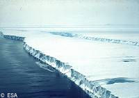
Data collected by the ESA's (European Space Agency) ERS satellite has revealed that a major glacial formation in Antarctica is shrinking. Scientists from University College London and the British Antarctic Survey have used the data to show that since 1992, 31 cubic kilometres of ice has been lost from the interior of the West Antarctic Ice Sheet (WAIS). The thinning has caused the glacier to retreat by over five kilometres inland, and has added ammunition to the argument that small changes at the coast of the Antarctic continent may be transmitted rapidly inland, leading to an acceleration of sea level rise. The height of the WAIS has been mapped with radar measurements from the ERS satellite altimeter, accurate to within 20 centimetres, at regular intervals since 1992. The data revealed a clear pattern of ice thinning within a 5000 square kilometre area of ice during the past 8 years.