

ESA satellites help WWF to identify potential 'urban hotspots'
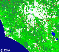
The European Space Agency (ESA) has teamed up with environmental organisation WWF Italia and technology company Advanced Computer Systems (ACS) to use satellite imagery to fight the over development of Italy's costal areas. As part of ESA's Urban Expansion (UrbEx) programme aimed at using Earth observation data to solve environmental problems, the project aimed to develop a database of images and analytical tools to assess the growth of urbanisation and its impact on natural resources. 'We are interested in monitoring coastal areas and looking for such things as illegal construction, new roads, expansion of ports and tourist facilities, degradation of natural vegetation regions like wetlands and dunes, and water pollution from civil and industrial sewage,' explains Andrea Masullo from WWF Italia. 'We want to identify hot spots and investigate before it's too late to do anything about the environmental impact,' he said. The new web based service allows WWF Italia to access maps providing different types of land use analyses depending on the issues of concern. Changes in land use are highlighted in the maps, with the information having been derived from analyses of satellite imagery taken from 1994 onwards. The service currently covers an area of 200,000 square kilometres, almost two thirds of Italy's total, and ACS is looking at the possibility of further developing the service and marketing it commercially. Potential users could include governmental bodies at local, national and European levels, statistical agencies handling census data, and commercial mapping companies.
Countries
Italy