

Sharper satellite images help to verify compliancy with agricultural regulations
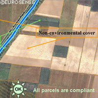
Checking compliancy with the rules of the Common Agricultural Policy (CAP) is to become faster and easier with new, sharper images provided by a very high resolution (VHR) satellite. The project demonstrating how Earth observation satellites can be used in conjunction with the CAP was funded by the European Space Agency (ESA). In order to receive subsidies from the European Union, farmers must keep their land in Good Agricultural and Environmental Condition (GAEC). The satellite images can be used by the authorities to confirm compliance with CAP regulations, and by farmers, who can use them to submit more accurate applications. High resolution satellites as well as aerial photography have been used for some time to monitor areas eligible for CAP funding. VHR Earth observation satellites offer more detail than the older high resolution (HR) satellites: they are capable of identifying various landscape features and detecting potential erosion and tillage practices, as well as how pastures are being maintained. GAEC standards stipulate that farmers may not remove certain landscape features, including hedges, tree rows, water ponds, walls and single trees, without permission from national authorities. The rules are intended to preserve habitats for Europe's organisms and species. The VHR satellite images can be used to identify these landscape features. In combination with digital aerial images, even single trees can be pin pointed. A comparison between older and more recent images of the same area shows clearly if any features have been removed. In order to receive subsidies for permanent crops, the GAEC requires that farmers keep them well maintained. VHR images show clearly when crops have been well looked after, and when poor maintenance is a possibility. This allows the authorities to visit the fields in order to verify whether crops have been abandoned or neglected.