

ESA satellites survey fires across Europe
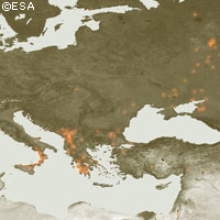
As hot spots across Southeastern Europe go up in flames, the satellites of the European Space Agency (ESA) have been surveying the fires. Working like thermometers in the sky, the Along Track Scanning Radiometer (ATSR) on ESA's ERS-2 satellite, and the Advanced Along Track Scanning Radiometer (AATSR) on ESA's Envisat satellite, have been measuring thermal infrared radiation to take the temperature of Earth's land surfaces. Temperatures exceeding 312°Kelvin (38.85°C) are classed as burning fires by AATSR. ESA has been able to produce worldwide fire maps available to users online in near-real time. Smoke from some of the fires included in the fire map has also been detected by Envisat's Medium Resolution Imaging Spectrometer (MERIS) optical instrument. While working in Full Resolution mode to provide a spatial resolution of 300 metres, MERIS captured smoke plumes rising from fires raging across Greece's southern Peloponnese peninsula. The blazes have already claimed the lives over 60 people since they began five days ago. ESA has made these images available on its MIRAVI website, which gives access to Envisat's most recently acquired images. MIRAVI (MERIS Images RApid Visualisation) tracks Envisat - the world's largest Earth Observation satellite - around the globe, generates images from the raw data collected by MERIS and provides them online within two hours. MERIS is also being used in combination with other satellite sensors for the Risk-EOS initiative, a series of operational services for fire and flood risk management. Risk-EOS is part of the Services Element of 'Global Monitoring for Environment and Security' (GMES), a joint initiative supported by ESA and the European Commission. The goal of GMES is to establish an independent European capability for worldwide environmental monitoring.