Advanced methods and techniques for habitat monitoring
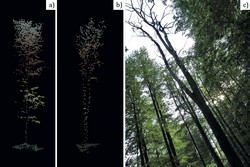
The project CHANGEHABITATS 2(opens in new window) (Network for habitat monitoring by airborne-supported field work – An innovative and effective process in implementation of the Habitat Directive) has advanced procedures and software solutions for monitoring and mapping habitats using innovative techniques for acquiring airborne data. To realise its goals, the project engaged data producers, data processors and end users to build a network joining industry and academia. Work concentrated on two complementary remote sensing (RS) data acquisition methods gaining popularity: airborne laser scanning (ALS) and airborne hyperspectral imagery (HS). Researchers compiled information on the availability, quality and compatibility of existing habitat data into two reports. The partners evaluated the methods for their potential for manual and automatic derivation of habitat parameters. They collected ALS data from 10 flight campaigns for a steppe forest, alkali grasslands and floodplain forests in eastern Hungary. In western Hungary and east Germany they concentrated on beech forests. ALS enabled categorisation of grassland vegetation, estimation of deadwood and vegetation layers in forests, and habitat quality monitoring of alkali grasslands. HS was used for mapping grass species in western Hungary. CHANGEHABITATS 2 also conducted field work at these sites on habitat mapping. These included important habitat characteristics regarding nature conservation and remote sensing. The habitat features from the field work were correlated with structural parameters from aerial survey for automatic deduction of habitat parameters. This enabled implementation of automatic forest layer identification from ALS data according to Natura 2000 specification. Other application and modelling exercises showed that ALS and HS data results for habitat assessment are compatible with the existing field-based approach. Following, the team generated new inputs for rapid development of data processing and interpretation technologies relevant to complex land cover. The new approach for habitat quality assessment meets Natura 2000 monitoring requirements. Project work and ongoing efforts promise savings close to a billion euros along with less laborious and more economical field work and more homogeneous and accurate data. The developments also open a new market for data acquisition devices and services related to environmental monitoring and protection.