Safe efficient driving via next-generation in-vehicle navigation systems
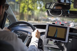
Autonomous technology is reshaping the future of the automotive industry. EU-funded researchers working on the INLANE(opens in new window) project developed a cutting-edge positioning solution to support the growth of this rapidly changing industry. The new system takes the global navigation satellite system (GNSS) to the next level by providing drivers with access to real-time maps and lane-level navigation, creating an accurate navigation experience. The need for advanced functionalities Lane determination is an important feature of advanced automotive navigation and guidance systems. It provides drivers with comprehensive information about the precise position of the vehicle on the road as well as guidance and control. “Lane-level positioning and map matching have been overlooked by current navigation systems. We need more accurate and reliable positioning systems to cater for the growing demand for applications such as enhanced driver awareness, intelligent speed alert and simple lane allocation,” notes project coordinator Dr Oihana Otaegui. In general, today’s in-vehicle navigation systems are great at getting us to a certain point, but they tend to lack the details. Information about lane navigation is not based on the real position of the vehicle on a multi-lane road but is rather in the form of a simple line depicting the road direction of travel. This together with real-time voice alerts might put a stress and confuse the driver, causing him to miss a turn or exit a highway at the wrong point. Navigation technology in the fast lane To get the necessary level of accuracy, the INLANE project worked to fuse the precision of European GNSS (Galileo) with computer vision technology and sensor data. By combining these technologies, researchers created the first low-cost, next-generation navigation system capable of providing lane-level and precise turn-by-turn navigation. More specifically, the INLANE system takes advantage of European Geostationary Navigation Overlay Service (EGNOS)(opens in new window), which improves the accuracy and reliability of the European GNSS positioning information. INLANE proves that combining this flexible low-cost navigation solution with low-cost sensors such as inertial measurement unit devices and cameras offers an unprecedented solution for precise vehicle location, real-time continuous map updates, local dynamic maps and scenery recognition. “We only rely on the use of affordable cameras instead of light detection and ranging (LIDAR) technology for detecting cars, obstacles and signs. A single 32-channel LIDAR can cost more than the vehicle itself,” explains Dr Otaegui. The path to highly autonomous vehicles The main result of INLANE is a set of software components that provide detailed and accurate lane-level positioning in turn-by-turn navigation systems. Once fully functional, the system will have multiple applications for future connected and autonomous vehicles by providing the positional accuracy needed for self-driving transport, while enhancing location information used in vehicle-to-vehicle and vehicle-to-infrastructure communications. “By delivering lane-level information to an in-vehicle navigation system, and combining this with the opportunity for vehicles to exchange information, drivers will be able to select the optimal lane for travel, even in dense traffic,” adds Dr Otaegui. With the INLANE system, drivers should be able to choose the appropriate lane for exiting, thus reducing the risks associated with the last-moment lane changes that are all too common on our busy expressways.