

European space initiative aids flood forecasting in Canada
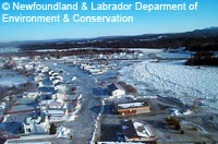
An EU-led initiative is helping residents of a flood-prone community in Canada to predict when their town is likely to be hit by flash floods. Badger, a small town with around 900 inhabitants, is situated in central Newfoundland and Labrador, at the confluence of three rivers. On the morning of 15 February 2003, a build up of ice in the Exploits River caused the river to burst its banks. The water flowed into the town, and in less than an hour the water level rose by 2.3 metres. The disaster was compounded by sub-zero temperatures which froze the flood waters, encasing much of the town in ice for a number of weeks. The entire town had to be evacuated and many homes and buildings were destroyed. While the 2003 flood was the most severe to hit Badger, it was by no means the first. Until recently, flood prediction in the town relied on ice-monitoring carried out by observers - usually town officials and staff from a nearby paper mill. However, making regular observations was often difficult and dangerous, particularly during adverse weather conditions. Now the EU's GMES (Global Monitoring for Environment and Security) initiative is helping the people of Badger to predict when a flood is imminent. GMES is an EU-led initiative in partnership with the European Space Agency (ESA) that combines ground- and space-based observations to develop an integrated environmental monitoring capability to benefit end-users. Through GMES, the Newfoundland and Labrador Department of Environment and Conservation is able to access remote sensing data, which it combines with data from its own satellites, weather forecasts and field observations to create the flood forecasting service. Ice conditions on the rivers near Badger are monitored, and when the situation on the river becomes dangerous, alerts are issued to the relevant authorities. The flood forecasting service has also been available online since February 2006. Newfoundland and Labrador Minister within the Department of Environment and Conservation Clyde Jackman is enthusiastic about the benefits of using radar imagery to predict floods. 'The radar imagery offers a 'big picture' view of a large segment of the Exploits River at one instance and is able to work in all weather as the radar sees through rain, snow and fog,' he said. 'Based on our experience with the 2003 flood, I believe the use of radar imagery would have significantly improved our ability to provide a timely forecast and to direct the post flood response.'
Countries
Canada