


Envisat images reveal extent of fires and floods
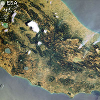
The full extent of the fires and floods that are currently causing misery for millions of Europeans is revealed by satellite images released by the European Space Agency (ESA). The images, taken by the Envisat satellite, clearly show the worst floods to hit the UK for 60 years, as well as the deadly fires which are raging across large areas of southern Europe. In the UK, heavy rains have caused rivers across central and southern England and Wales, including the Thames and the Severn, to burst their banks. Half a million homes have been affected by the floods, which have left towns and vast swathes of the countryside underwater. Tens of thousands have been left without electricity or running water. According to the ESA, one of the biggest problems during a flood is obtaining an overview of the extent of the area affected. Obtaining information from the air is often difficult due to the weather conditions, and if the floods are widespread aerial observation is often too time-consuming and expensive. As floods are often visible from space, Earth Observation (EO) satellites are increasingly being used to provide information to emergency services involved in flood response and mitigation. In 2000, the European and French space agencies launched that International Charter on 'Space and Major Disasters', which provides satellite data free of charge to those affected by natural or man made disasters anywhere in the world. Resources for the initiative come from the member agencies. The service can only be activated by Authorised Users, who place a call via a line which is manned 24 hours a day. The operator passes the information to the Emergency On-Call Officer who analyses the scale of the disaster with the Authorised User and prepares a plan to get hold the data needed as soon as possible. The UK's Environment Agency requested the aid of the charter on 24 July. Meanwhile several southern European countries are battling with soaring temperatures and wildfires which have consumed thousands of hectares of countryside. In the worst cases, tourists and local residents alike have been forced to flee to beaches to escape the flames. The ESA's satellites are able to detect the smoke from major fires as well as the burn scars they leave behind. Infra-red scanning of the Earth's surface also shows the fires themselves as 'hotspots'. The fire data is made available in near-real time via the World Fire Atlas.