Satellite systems in the same lane as driver safety systems
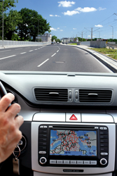
Advanced driver assistance systems (ADAS) include collision avoidance systems, lane departure warning and blind spot detection, which as all drivers know can help to avoid an accident. As such their accuracy and reliability would improve if they could be integrated with satellite positioning services like Galileo. The EU-funded project Gallant aimed to study exactly how feasible and precisely what advantages would be gained if 'Global navigation satellite service' (GNSS) was merged with advanced driver assistance onboard applications. Having a reliable and certified positioning service means that the system will warn the user when the positioning system is down as well as resolving circumstances not detectable by on-board sensors. The targeted ADAS include those designed to save lives and as such require a high degree of accuracy, continuity and availability. Being linked to high quality digital maps gives a precise and accurate reconstruction of the scenario – an absolute must for all safety related automatic actions. The Gallant simulator has a high degree of modularity where the system is divided into smaller sub-systems that interact with each other. Predictive cruise control which sets the speed of the vehicle according to the environment is possible whereas previously this was input by the user. Indeed, any generic scenario can be converted to a simulation including those with features like obstacles and urban canyons where streets cut through tall buildings. For the driver, a user-friendly graphical interface is a particular advantage as the system features are presented as on any windows-based tool. For example, a toolbar allows the user to manage the simulator. A major breakthrough is that the European Geostationary Navigation Overlay Service (EGNOS) has been integrated with the in-vehicle road transport application. EGNOS supports Galileo and GPS by reporting on the reliability and accuracy of signals. The Gallant system heralds the launch of a driver assistance service that is sophisticated enough to intervene in car functions to save lives. Road users globally can look forward to safer travelling even at a time when road use is still accelerating