

ESA satellite used in battle against Canadian forest fires
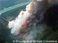
REMSAT, a European Space Agency (ESA) supported satellite ground station is supplying up to the minute fire mapping and logistics support to firefighters battling against forest fires in Canada. The ground station, which is housed in a container and carried by a truck or helicopter to a point very close to the fire, was used recently in the fight to bring two 'project fires' under control. Project fires require a full incident management team, with logistical and administrative support as well as camp facilities for crews. 'We had no access to any type of non-satellite based telephone service,' said Steve Newton, manager of the lillooet fire zone for Canada's Kamloops fire centre. 'FM radio for the area also had severe limitations and had to be supplemented with local temporary repeaters set up exclusively for this project.' Both fires were located in extremely rugged and steep terrain, with most of the area within and around the fire perimeters only accessible by helicopter. In addition to this, glaciers with slopes in excess of 100 per cent cascade out from between these mountain ranges, and the area is also used for the relocation of grizzly bears. 'Firefighters were quick to appreciate the value of REMSAT,' explained Mr Newton. 'They were like children in a candy store when the IKONOS imagery arrived via the downlink to the field. The incident management team and other operations personnel were amazed at our ability to deliver such high quality one metre resolution imagery to the middle of nowhere. 'Once the satellite link was established,' Newton continued, 'we were able to download archived satellite imagery and GIS data sets almost immediately to begin our mapping. We then took the incident management team's hand drawn maps and digitised a preliminary perimeter for each fire. The next day we walked and flew the perimeters and control lines and generated some GPS data sets, which gave us a more accurate picture of what was out there,' he said.