

EU research reveals the surface effects of earthquakes
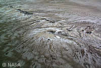
Researchers from the Commission's Joint Research Centre (JRC) have revealed findings from the 2001 earthquake in Gujarat, India, which will provide valuable information for the future analysis of earthquakes. Using data provided by the multi-angle imaging spectroradiometer (MISR) onboard NASA's Terra satellite, the JRC team, together with scientists from the US, France and Germany, were able to analyse regions affected by the disaster that land-based survey teams could not. They discovered that the earthquake, which claimed nearly 20,000 lives, also triggered the release of ground water and sediments over a wide area, reactivating ancient rivers and forming shallow lakes. It was also discovered that this 'dewatering' phenomenon included a process known as liquefaction, which causes sediments to behave more like liquids than solids during earthquakes, and can lead to severe damage to buildings. European Research Commissioner, Philippe Busquin, said: 'This is key information, especially when considering the humanitarian and economic impacts of such disasters. [...] The successful collaboration at EU and international level illustrates the benefits that can be expected from coordinated approaches such as under the global monitoring for environment and security (GMES) initiative.' The discovery of the sudden appearance of surface water around the earthquake's epicentre was made possible thanks to the unique capability of MISR to view the sunlit surface of the Earth at nine different angles and at four spectral bands. The Commission has also exploited data from MISR to detect and characterise the properties of atmospheric aerosols over land, and to estimate land surface properties based on their spectral and directional signatures. EU researchers also aim to use MISR to develop novel algorithms that will provide information about the status of land surfaces. 'Advanced space technology has helped to monitor various surface effects of earthquakes accurately and efficiently,' added Mr Busquin. 'We are currently building, in cooperation with the European Space Agency and national space agencies, a space policy for the EU so that space-based intelligence can be put at the service of our different policy objectives.'