Monitoring deforestation with increased accuracy
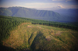
The CARBO_INVENT project set up a system for quantification of carbon stock and stock changes at national scales for European forests. More specifically, researchers specified, developed and used multi-source inventory methods to meet the reporting commitments of the United Nations Framework Convention on Climate Change (UNFCCC) and the Kyoto Protocol. Part of project work involved detection of deforestation events and estimation of the area by employing multi-temporal remote sensing imagery. This was conducted for the aim of reporting to the Annex B Parties of the Kyoto Protocol about carbon stock changes and non-CO2 greenhouse gas emissions. Investigation was run for the commitment period since 1990 on land areas subjected to direct human-induced deforestation activities that were related to the conversion of forest to non-forest land. For certain distant areas, where no field deforestation data coming from national inventories were available, remote sensing methods were used for assessing the applicability of Landsat data. Landsat data collected during the past two decades is available free of charge for the majority of areas worldwide and feature high resolution imagery, which is particularly important for remote areas. The minimum area definition, the spatial resolution of the remote sensing imagery and the change characteristics are key parameters for the detection of deforestation events. In order to increase the interpretation accuracy, methods for fusion of the recent panchromatic Landsat data with the multi-spectral bands were created. Although Landsat data can detect very accurately and cost-effectively large deforestation events (of 1ha), for smaller deforestation events further information is required. Thereby, in addition to the wall-to-wall mapping (full aerial coverage) coming from the Landsat data, estimation of the probability distribution of the aerial extend of the deforestation events is also needed.